Cleeve Hill
| Cleeve Hill | |
|---|---|

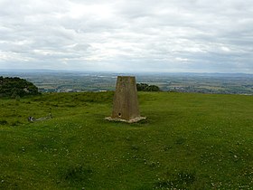
The trig point on the northern part of Cleeve Hill at SO985263. There is also a toposcope at this location
|
|
| Highest point | |
| Elevation | 1,083 ft (330 m) |
| Prominence | 794 ft (242 m) |
| Parent peak | The Wrekin |
| Listing | Marilyn, County Top |
| Coordinates | 51°55′12″N 2°00′25″W / 51.920°N 2.007°WCoordinates: 51°55′12″N 2°00′25″W / 51.920°N 2.007°W |
| Geography | |
| Location | Gloucestershire, England |
| Parent range | Cotswolds |
| OS grid | SO996246 |
| Topo map |
OS Landranger 163 OS Explorer 179 |
| Geology | |
| Age of rock | Jurassic |
| Mountain type | Sedimentary |
| Climbing | |
| Easiest route | Hike |
OS Landranger 163
Cleeve Hill (also known as Cleeve Cloud) is the highest point both of the Cotswolds hill range and in the county of Gloucestershire, at 1,083 feet (330 m). It is located on Cleeve Common which is a Site of Special Scientific Interest (SSSI) looked after by a small charity called Cleeve Common Board of Conservators. It commands a clear view to the west, over Cheltenham and the racecourse, over the River Severn and into Wales; and to the north over Winchcombe. It is a conspicuous outcrop on the edge of the limestone escarpment, (sometimes called the "Cotswold Edge"). It is crossed by the Cotswold Way footpath.
With the hill's south slopes draining to the River Coln, Cleeve Hill is the highest point in the drainage basin of the River Thames.
The summit, at 1,083 ft (330 m), is a nondescript point marked by a trig point on the relatively flat common south of the Hill. Because of this, it does not offer particularly wide-ranging views. To the North by north-west, another summit at 1,033 ft (315 m) high boasts a toposcope and a trig-point, offering far wider views. On an exceptionally clear day (for example a sunny day following a day of rain in spring or early summer), the view extends an impressive 90 miles (140 km) to Winsford Hill on Exmoor, Somerset.
...
Wikipedia

