Worth Township, Butler County, Pennsylvania
| Worth Township, Butler County, Pennsylvania |
|
|---|---|
| Township | |

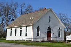
Wolf Creek Presbyterian Church
|
|
 Map of Butler County, Pennsylvania highlighting Worth Township |
|
 Map of Butler County, Pennsylvania |
|
| Country | United States |
| State | Pennsylvania |
| County | Butler |
| Settled | 1790 |
| Incorporated | 1854 |
| Area | |
| • Total | 25.2 sq mi (65.3 km2) |
| • Land | 24.2 sq mi (62.8 km2) |
| • Water | 1.0 sq mi (2.5 km2) |
| Population (2010) | |
| • Total | 1,416 |
| • Density | 59/sq mi (22.6/km2) |
| Time zone | Eastern (EST) (UTC-5) |
| • Summer (DST) | EDT (UTC-4) |
| Website | www |
Worth Township is a township in Butler County, Pennsylvania, United States. The population was 1,416 at the 2010 census.
Worth Township is located in northwest Butler County, along its border with Lawrence County. It includes the unincorporated communities of Jacksville and Moores Corners. Interstate 79 runs north-south through the township, with access from Exit 105 (Pennsylvania Route 108) in the north and Exit 99 (U.S. Route 422) just south of the township border. Slippery Rock Creek flows through the northern corner of the township, and Muddy Creek forms the township's southern boundary. The creek is impounded to form Lake Arthur, which is surrounded by Moraine State Park, a recreational area.
According to the United States Census Bureau, the township has a total area of 25.2 square miles (65.3 km2), of which 24.2 square miles (62.8 km2) is land and 0.97 square miles (2.5 km2), or 3.89%, is water.
As of the census of 2000, there were 1,331 people, 473 households, and 377 families residing in the township. The population density was 54.9 people per square mile (21.2/km²). There were 543 housing units at an average density of 22.4/sq mi (8.6/km²). The racial makeup of the township was 98.27% White, 0.53% Asian, 0.38% from other races, and 0.83% from two or more races. Hispanic or Latino of any race were 0.53% of the population.
...
Wikipedia
