Wookey Hole Caves
| Wookey Hole Caves | |
|---|---|

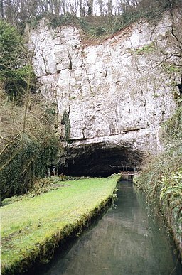
The River Axe emerging from Wookey Hole Caves
|
|
| Location | Wookey Hole, Somerset, UK |
| OS grid | ST 5319 4802 |
| Coordinates | 51°13′46″N 2°40′18″W / 51.229308°N 2.671776°WCoordinates: 51°13′46″N 2°40′18″W / 51.229308°N 2.671776°W |
| Depth | 90 metres (300 ft) |
| Length | 3,890 metres (12,760 ft) |
| Height variation | 141 metres (463 ft) |
| Elevation | 64 metres (210 ft) |
| Geology | Dolomitic conglomerate and limestone |
| Entrances | 6 (incl. 1 artificial, 1 blocked) |
| Access | Restricted |
| Show cave opened | 1927 |
| Lighting | Electric |
| Pronunciation | [/ˈwʊki ˈhoʊl/] |
| Registry | MCRA |
Wookey Hole Caves are a series of limestone caverns, a show cave and tourist attraction in the village of Wookey Hole on the southern edge of the Mendip Hills near Wells in Somerset, England. The River Axe flows through the cave. It is a Site of Special Scientific Interest (SSSI) for both biological and geological reasons. Wookey Hole cave is a "solutional cave", one that is formed by a process of weathering in which the natural acid in groundwater dissolves the rocks. Some water originates as rain that flows into streams on impervious rocks on the plateau before sinking at the limestone boundary into cave systems such as Swildon's Hole, Eastwater Cavern and St Cuthbert's Swallet; the rest is rain that percolates directly through the limestone. The temperature in the caves is a constant 11 °C (52 °F).
The caves have been used by humans for around 45,000 years, demonstrated by the discovery of tools from the Palaeolithic period, along with fossilised animal remains. Evidence of Stone and Iron Age occupation continued into Roman Britain. A corn-grinding mill operated on the resurgent waters of the River Axe as early as the Domesday survey of 1086. The waters of the river are used in a handmade paper mill, the oldest extant in Britain, which began operations circa 1610. The low, constant temperature of the caves means that they can be used for maturing Cheddar cheese.
...
Wikipedia

