Woodston, Kansas
| Woodston, Kansas | |
|---|---|
| City | |

Woodston City Office est 1910 (2016)
|
|
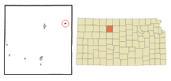
 Location within Rooks County and Kansas |
|
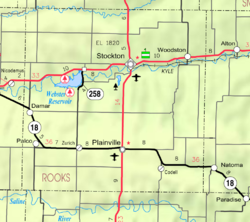
 KDOT map of Rooks County (legend) |
|
| Coordinates: 39°27′15″N 99°5′57″W / 39.45417°N 99.09917°WCoordinates: 39°27′15″N 99°5′57″W / 39.45417°N 99.09917°W | |
| Country | United States |
| State | Kansas |
| County | Rooks |
| Area | |
| • Total | 0.24 sq mi (0.62 km2) |
| • Land | 0.24 sq mi (0.62 km2) |
| • Water | 0 sq mi (0 km2) |
| Elevation | 1,713 ft (522 m) |
| Population (2010) | |
| • Total | 136 |
| • Estimate (2015) | 136 |
| • Density | 570/sq mi (220/km2) |
| Time zone | CST (UTC-6) |
| • Summer (DST) | CDT (UTC-5) |
| ZIP code | 67675 |
| Area code | 785 |
| FIPS code | 20-80450 |
| GNIS feature ID | 0472253 |
Woodston is a city in Rooks County, Kansas, United States. As of the 2010 census, the city population was 136.
The town of Woodston was established along the Missouri Pacific Railroad in 1885 as a railroad town between Bull City (Alton) and . Woodston was named for Stockton businessman Charles C. Woods who was instrumental in getting railroad service to Stockton.
The Rooks Centre Post Office, established in 1872, was moved to Woodston in 1886.
Woodston filed for incorporation in 1905.
Woodston is located at 39°27′15″N 99°5′57″W / 39.45417°N 99.09917°W (39.454301, -99.099116). According to the United States Census Bureau, the city has a total area of 0.24 square miles (0.62 km2), all of it land.
As of the census of 2010, there were 136 people, 53 households, and 38 families residing in the city. The population density was 566.7 inhabitants per square mile (218.8/km2). There were 82 housing units at an average density of 341.7 per square mile (131.9/km2). The racial makeup of the city was 94.9% White, 1.5% African American, 2.9% Asian, and 0.7% from two or more races. Hispanic or Latino of any race were 0.7% of the population.
...
Wikipedia
