Woodhaven and Cross Bay Boulevards
 |
|

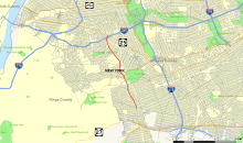
Map of Woodhaven Boulevard
|
|
| Former name(s) | Jamaica Bay Boulevard |
|---|---|
| Length | 11 mi (18 km) |
| Location | Queens, New York City, New York |
| South end | Beach Channel Drive in Rockaway Beach |
| Major junctions |
Rockaway Boulevard / Liberty Avenue in Ozone Park Myrtle Avenue in Forest Park Union Turnpike in Glendale |
| North end |
|
Woodhaven Boulevard and Cross Bay Boulevard (formerly Jamaica Bay Boulevard) are two parts of a major boulevard in the New York City borough of Queens. Woodhaven Boulevard runs roughly north–south in the central portion of Queens. South of Liberty Avenue, it is known as Cross Bay Boulevard, which is the main north–south road in Howard Beach. Cross Bay Boulevard is locally known as simply "Cross Bay", and Woodhaven Boulevard, "Woodhaven". The completion of the boulevard in 1923, together with the construction of the associated bridges over Jamaica Bay, created the first direct roadway connection to the burgeoning Atlantic Ocean beachfront communities of the Rockaway Peninsula from Brooklyn and most of Queens.
The road is part of the New York City Arterial System with the unsigned reference route designation of New York State Route 908V (NY 908V), but is still maintained by the New York City Department of Transportation.
Beginning at the intersection with Queens Boulevard near the Queens Center shopping mall in Elmhurst, the boulevard runs generally south through the neighborhoods of Rego Park, Elmhurst, Middle Village, Glendale, Woodhaven (for which it is named), and Ozone Park. At the intersection with Liberty Avenue in Ozone Park, the name of the street changes to Cross Bay Boulevard. It continues south through Ozone Park, Howard Beach and across Jamaica Bay via the Joseph P. Addabbo Memorial Bridge through Broad Channel, before finally coming to an end at Rockaway Beach in The Rockaways, after crossing over the Cross Bay Bridge.
...
Wikipedia
