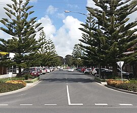
Wonthaggi, Victoria
|
Wonthaggi Victoria |
|||||||
|---|---|---|---|---|---|---|---|

Shopping Strip, McBride Avenue
|
|||||||
| Coordinates | 38°36′20″S 145°35′30″E / 38.60556°S 145.59167°ECoordinates: 38°36′20″S 145°35′30″E / 38.60556°S 145.59167°E | ||||||
| Population | 4,354 (2011 census) | ||||||
| Postcode(s) | 3995 | ||||||
| Elevation | 52 m (171 ft) | ||||||
| Location | |||||||
| LGA(s) | Bass Coast Shire | ||||||
| State electorate(s) | Bass | ||||||
| Federal Division(s) | McMillan | ||||||
|
|||||||
Wonthaggi /ˈwɒnθæɡi/ is a seaside town located 132 kilometres (82 mi) south east of Melbourne via the South Gippsland and Bass Highways, in the Bass Coast Shire of Gippsland, Victoria, Australia. Known originally for its coal mining it is now the largest town in South Gippsland, a regional area with extensive tourism, beef and dairy industries.
The name "Wonthaggi" is an Australian Aboriginal name meaning "home" from the Bunurong (south-central Kulin). It was used in the area some time before 1 August 1910 when the town was founded.
The Bunurong aboriginal people were custodians of this stretch of coast for thousands of years prior to white settlement. The Boakoolawal clan lived in the Kilcunda area south of the Bass River, and the Yowenjerre were west of the Tarwin River along what is now the Bunurong Marine and Coastal Park. Middens containing charcoal and shellfish mark the location of their campsites along the coast.
...
Wikipedia

