Wollombi, New South Wales
|
Wollombi Cessnock, New South Wales |
|||||||
|---|---|---|---|---|---|---|---|

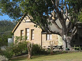
Wollombi Public School
|
|||||||
| Coordinates | 32°55′54″S 151°08′04″E / 32.93167°S 151.13444°ECoordinates: 32°55′54″S 151°08′04″E / 32.93167°S 151.13444°E | ||||||
| Population | 264 (2006 census) | ||||||
| Postcode(s) | 2325 | ||||||
| Elevation | 80 m (262 ft) | ||||||
| Time zone | AEST (UTC+10) | ||||||
| • Summer (DST) | AEDT (UTC+11) | ||||||
| Location | |||||||
| LGA(s) | Cessnock City Council | ||||||
| Region | Hunter | ||||||
| County | Northumberland | ||||||
| Parish | Corrabare | ||||||
| State electorate(s) | Cessnock | ||||||
| Federal Division(s) | Hunter | ||||||
|
|||||||
Wollombi is a small village in the Hunter Region of New South Wales, Australia. It is within the Cessnock City Council LGA, situated 29 kilometres (18 mi) southwest of Cessnock and 128 km (80 mi) north of Sydney. To the south is the village of Laguna, to the east, the village of Millfield and to the north, the village of Broke.
The valley is bordered to the west by the World Heritage listed Yengo National Park (and Yengo State Forest) and the main road, the convict-built Great North Road (GNR) forms one of the major legs of the Greater Blue Mountains Drive. To the east lie Watagans National Park along with Corrabare and Olney State Forests.
Wollombi's modest modern size is offset by its 19th-century sandstone buildings and timber slab constructed cottages and sheds in a narrow valley junction containing Wollombi Brook and Congewai Creek. Narone and Yango Creeks also join these waterways near the village.
The area is home to an abundance of native birds, reptiles and other animals including kangaroos, wallabies, wallaroos and wombats and is surrounded by imposing tree-lined mountains.
The traditional custodians of the locality are believed to be the Darkinjung people, though the Awabakal and Wanaruah nations are also mentioned.
...
Wikipedia

