Wolfe City, TX
| Wolfe City, Texas | |
|---|---|
| City | |

Main Street in October 2015
|
|
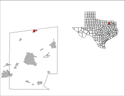
 Location of Wolfe City, Texas |
|
 |
|
| Coordinates: 33°22′5″N 96°4′14″W / 33.36806°N 96.07056°WCoordinates: 33°22′5″N 96°4′14″W / 33.36806°N 96.07056°W | |
| Country | United States |
| State | Texas |
| County | Hunt |
| Area | |
| • Total | 1.5 sq mi (4.0 km2) |
| • Land | 1.4 sq mi (3.7 km2) |
| • Water | 0.1 sq mi (0.2 km2) |
| Elevation | 692 ft (211 m) |
| Population (2000) | |
| • Total | 1,566 |
| • Density | 1,085.3/sq mi (419.0/km2) |
| Time zone | Central (CST) (UTC-6) |
| • Summer (DST) | CDT (UTC-5) |
| ZIP code | 75496 |
| Area code(s) | 903 |
| FIPS code | 48-79948 |
| GNIS feature ID | 1376856 |
Wolfe City is a city in Hunt County, Texas, United States located at the intersection of state highways 34 and 11. It is approximately seventeen miles north of Greenville in north central Hunt County, and was settled in the 1860s or 1870s when J. Pinckney Wolfe built a mill near the banks of Oyster Creek. The population was 1,566 at the 2000 census.
Wolfe City is located at 33°22′05″N 96°04′14″W / 33.367996°N 96.070430°W (33.367996, -96.070430).
According to the United States Census Bureau, the city has a total area of 1.5 square miles (3.9 km2), of which, 1.4 square miles (3.6 km2) of it is land and 0.1 square miles (0.26 km2) of it (5.84%) is water.
As of the census of 2000, there were 1,566 people, 615 households, and 413 families residing in the city. The population density was 1,085.3 people per square mile (419.9/km2). There were 687 housing units at an average density of 476.1 per square mile (184.2/km2). The racial makeup of the city was 83.40% White, 13.09% African American, 1.02% Native American, 0.32% Asian, 0.06% Pacific Islander, 0.32% from other races, and 1.79% from two or more races. Hispanic or Latino of any race were 3.38% of the population.
...
Wikipedia
