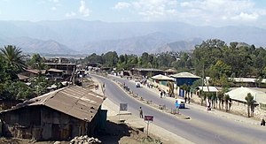
Woldiya
|
Woldia ወልደ Woldia or Woldiya |
|
|---|---|
 |
|
| Location within Ethiopia | |
| Coordinates: 11°49′50″N 39°36′0″E / 11.83056°N 39.60000°ECoordinates: 11°49′50″N 39°36′0″E / 11.83056°N 39.60000°E | |
| Country | Ethiopia |
| Region | Amhara |
| Zone | Semien Wollo Zone |
| Elevation | 2,112 m (6,929 ft) |
| Population (2017) | |
| • Total | 146,139 |
| Time zone | EAT (UTC+3) |
Woldia (also spelled Weldiya or Woldiya, "Wold/Weld" meaning "Son" in Ge'ez) is a hillside market town, capital of the Semien Wollo Zone, and woreda in northern Ethiopia. Located north of Dessie and southeast of Lalibela in the Amhara Region, this town has a latitude and longitude of 11°50′N 39°36′E / 11.833°N 39.600°E and an elevation of 2112 meters above sea level.
A notable landmark is the church Weldiya Gebri'el. Travertine for use in building has been worked on a minor scale nearby.
When the missionary Johann Ludwig Krapf passed through Weldiya in April 1842, it was the headquarters of Dejazmach Faris Aligas and his brother Birru. They were absent at the time of Krapf's visit, raiding the territories of Imam Liban of the Were Himano.
As early as 1890, Weldiya was the administrative center of Yejju Province. Its Tuesday market was well known for its mules. Weldiya was attacked in 1948 by the Yejju Oromo as part of the "Woyane Rebellion." Revolting after their appeals over their loss of land, they seized the prison in Weldiya and freed the prisoners. Despite this success, the revolt was eventually put down. On 16–17 November 1988 Weldiya was subjected to an aerial attack by the Derg, but no deaths were reported.
Based on the 2007 national census conducted by the Central Statistical Agency of Ethiopia (CSA), this town has a total population of 46,139, of whom 23,000 are men and 23,139 women. The majority of the inhabitants practiced Ethiopian Orthodox Christianity, with 80.49% reporting that as their religion, while 18.46% of the population said they were Muslim.
...
Wikipedia

