Wiseman, Alaska
| Wiseman, Alaska | |
|---|---|
| CDP | |

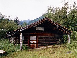
The log-built post office at Wiseman, seen here in 1995, has been sinking into the ground for the past century, and is now a couple of feet below ground.
|
|
 Location of Wiseman, Alaska |
|
| Coordinates: 67°24′34″N 150°6′35″W / 67.40944°N 150.10972°WCoordinates: 67°24′34″N 150°6′35″W / 67.40944°N 150.10972°W | |
| Country | United States |
| State | Alaska |
| Census Area | Yukon-Koyukuk |
| Government | |
| • State senator | Donny Olson (D) |
| • State rep. | Dean Westlake (D) |
| Area | |
| • Total | 78.1 sq mi (202.4 km2) |
| • Land | 78.1 sq mi (202.3 km2) |
| • Water | 0.0 sq mi (0.1 km2) |
| Elevation | 1,181 ft (360 m) |
| Population (2010) | |
| • Total | 14 |
| • Density | 0.18/sq mi (0.069/km2) |
| Time zone | Alaska (AKST) (UTC-9) |
| • Summer (DST) | AKDT (UTC-8) |
| Area code | 907 |
| FIPS code | 02-85610 |
| GNIS feature ID | 1414284 |
Wiseman is a census-designated place (CDP) in Yukon-Koyukuk Census Area, Alaska, United States. The population was 14 at the 2010 census.
Wiseman is a small mining community along the Middle Fork Koyukuk River in the Brooks Range. It was founded by gold miners who abandoned the Slate Creek (later Coldfoot) settlement around 1908.
Robert Marshall, who became a prominent American forester, preservation activist, and a co-founder of The Wilderness Society, wrote the bestselling book, Arctic Village, about his 15-month stay in this frontier town around the year 1930. Marshall described Wiseman and the Koyukuk River area surrounding it, as the happiest civilization of which I have knowledge." The community is 3 miles (5 km) from the Dalton Highway, and it was not connected to the road until the early 1990s.
Wiseman is located at 67°26′0″N 150°5′40″W / 67.43333°N 150.09444°W (67.433355, -150.094376).
According to the United States Census Bureau, the CDP has a total area of 78.1 square miles (202 km2), of which, 78.1 square miles (202 km2) of it is land and 0.04 square miles (0.10 km2) of it (0.05%) is water. The town is bisected by Wiseman Creek.
...
Wikipedia
