Winter of 2009–2010 in the United Kingdom

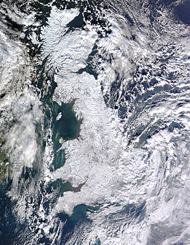
Satellite photo of Great Britain and eastern Ireland showing the extent of snow cover. This photo was taken on 7 January 2010 following consecutive days of snow.
|
|
| Formed | 16 December 2009 |
|---|---|
| Lowest temperature | −22.3 °C (−8.1 °F) (8 January, Altnaharra, Scottish Highlands) |
| Maximum snowfall or ice accretion | 61 centimetres (24 in) (26 February, Aviemore, Highland) |
| Areas affected | United Kingdom (rest of northern Europe) |
The winter of 2009–10 in the United Kingdom (also called The Big Freeze by British media) was a meteorological event that started on 16 December 2009, as part of the severe winter weather in Europe. January 2010 was provisionally the coldest January since 1987 across the country. A persistent pattern of cold northerly and easterly winds brought cold, moist air to the United Kingdom with many snow showers, fronts and polar lows bringing snowy weather with it.
The first snowfall began on 17 December 2009, before a respite over the Christmas period. The most severe snowy weather began on 5 January in North West England and west Scotland with temperatures hitting a low of −17.6 °C (0.3 °F) in Greater Manchester, England. The snow spread to Southern England on 6 January and by 7 January the United Kingdom was blanketed in snow, which was captured by NASA's Terra satellite. The thaw came a week later, as temperatures started to increase.
The winter weather brought widespread transport disruption, school closures, power failures, the postponement of sporting events and 25 deaths. A low of −22.3 °C (−8.1 °F) was recorded in Altnaharra, Scotland on 8 January 2010. Overall it was the coldest winter since 1978–79, with a mean temperature of 1.5 °C (34.7 °F).
On 16 December forecasters warned of very heavy snowfall to come. A band of rain moved southwards over the UK, which brought some snow. Snow fell in Kent, Surrey, Sussex and Hampshire, which brought some disruption. Day time temperatures were around 0 °C (32 °F) and a low of −7.4 °C (18.7 °F) was recorded in Surrey.
On the 17th, easterly winds brought heavier and persistent snow showers to eastern England and Scotland. Heavy snow showers brought accumulation up to 3 cm in Aberdeenshire, Perth, Kinross and Fife, with some snow showers reaching Glasgow and western parts in the afternoon and evening. In Kent, motorists on the A21 were stuck for several hours during the evening and night.
...
Wikipedia
