Wind River Mountains
| Wind River Range | |
|---|---|

Wind River Range highcountry
|
|
| Highest point | |
| Peak | Gannett Peak |
| Coordinates | 43°11′04″N 109°39′12″W / 43.18444°N 109.65333°WCoordinates: 43°11′04″N 109°39′12″W / 43.18444°N 109.65333°W |
| Dimensions | |
| Length | 100 mi (160 km) NW/SE |
| Width | 30 mi (48 km) SW/NE |
| Area | 2,800 sq mi (7,300 km2) |
| Geography | |
| Country | United States |
| State | Wyoming |
| Parent range | Rocky Mountains |
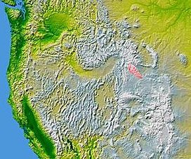
The Wind River Range (or "Winds" for short), is a mountain range of the Rocky Mountains in western Wyoming in the United States. The range runs roughly NW-SE for approximately 100 miles (161 km). The Continental Divide follows the crest of the range and includes Gannett Peak, which at 13,804 feet (4,207 m), is the highest peak in Wyoming. There are more than 40 other named peaks in excess of 13,000 feet (3,962 m). With the exception of the Grand Teton in the Teton Range, the next 19 highest peaks in Wyoming after Gannett are also in the Winds. Two large National Forests including three wilderness areas encompass most of the mountain range. Shoshone National Forest is on the eastern side of the continental divide while Bridger-Teton National Forest is on the west. Both National Forests and the entire mountain range are an integral part of the Greater Yellowstone Ecosystem. Portions of the range are also inside the Wind River Indian Reservation.
Indigenous peoples of the Great Basin, such as the Shoshones and Absarokas (Crow) Native Americans, lived in the range beginning 7000 and 9000 years ago. Villages as high as 10,000 feet in elevation, dating from 700 to 2000 BC, have recently been studied by archaeologists. These villages were established by the Sheepeater band of Shoshone during pine nut harvesting season. One, dubbed "High Rise", has 60 lodges over a space of 26 acres and was recently added to the National Register of Historic Places.
One of the men from the Lewis and Clark expedition, John Colter, is thought to be the first European American person to view the range when he visited the area around 1807, though little is known about his travels through the area. In 1812, a party led by Wilson Price Hunt were the first to cross South Pass, at the southern end of the range, the pass which marked the continental divide and crest of the Rocky Mountains and became an important portion of the Oregon Trail.
...
Wikipedia

