Wilton Junction, Iowa
| Wilton, Iowa | |
|---|---|
| City | |

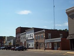
Buildings on the north side of West Fourth Street
|
|
| Motto: "Welcome Home!" | |
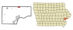
 Location of Wilton, Iowa |
|
| Coordinates: 41°35′22″N 91°1′3″W / 41.58944°N 91.01750°WCoordinates: 41°35′22″N 91°1′3″W / 41.58944°N 91.01750°W | |
| Country |
|
| State |
|
| Counties | Muscatine, Cedar |
| Founded | 1855 |
| Government | |
| • Type | Mayor-council government |
| • Mayor | Bob Barrett |
| Area | |
| • Total | 1.95 sq mi (5.05 km2) |
| • Land | 1.95 sq mi (5.05 km2) |
| • Water | 0 sq mi (0 km2) |
| Elevation | 679 ft (207 m) |
| Population (2010) | |
| • Total | 2,839 |
| • Estimate (2012) | 2,808 |
| • Density | 1,436.9/sq mi (554.8/km2) |
| Time zone | Central (CST) (UTC-6) |
| • Summer (DST) | CDT (UTC-5) |
| ZIP code | 52778 |
| Area code(s) | 563 |
| FIPS code | 19-86070 |
| GNIS feature ID | 0465185 |
| Website | City of Wilton, Iowa |
Wilton (formerly Wilton Junction) is a city in Cedar and Muscatine Counties in the U.S. state of Iowa. The population was 2,839 at the 2010 census. The Muscatine County portion of Wilton is part of the Muscatine Micropolitan Statistical Area.
The first white settler to build a home the area that was to be known as Wilton in the new state of Iowa (1846) was Mr. Christian Marolf who came in July 1849, and erected of a small log house opposite the German Lutheran church. When he built his home Mr. Marolf could only see one the home of Mr. Stearns just west of town on the south side of the Moscow road. Mr. Marolf was soon followed by Mr. Ben Maurer in 1850 whose land now comprises North Wilton and Peter Marolf in 1851, which is now known as Marolf's addition. North Wilton is at present (1947) not within the corporate limits of Wilton. The city was once home to the Wilton German English College from 1894 to 1905. The campus of the college was later turned into City Park, and some of the college's buildings remain to this day.
Wilton is at 41°35′22″N 91°1′3″W / 41.58944°N 91.01750°W (41.589350, -91.017487).
According to the United States Census Bureau, the city has a total area of 1.95 square miles (5.05 km2), all of it land. The city sits at an elevation of 679 feet.
As of the census of 2010, there were 2,802 people, 1,155 households, and 767 families residing in the city. The population density was 1,436.9 inhabitants per square mile (554.8/km2). There were 1,231 housing units at an average density of 631.3 per square mile (243.7/km2). The racial makeup of the city was 97.5% White, 0.3% African American, 0.1% Asian, 0.9% from other races, and 1.2% from two or more races. Hispanic or Latino of any race were 2.6% of the population.
...
Wikipedia
