Williston, South Carolina
| Williston, South Carolina | |
|---|---|
| Town | |
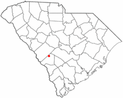
 Location of Williston, South Carolina |
|
| Coordinates: 33°24′2″N 81°25′21″W / 33.40056°N 81.42250°WCoordinates: 33°24′2″N 81°25′21″W / 33.40056°N 81.42250°W | |
| Country | United States |
| State | South Carolina |
| County | Barnwell |
| Area | |
| • Total | 9.0 sq mi (23.3 km2) |
| • Land | 9.0 sq mi (23.2 km2) |
| • Water | 0.08 sq mi (0.2 km2) |
| Elevation | 354 ft (108 m) |
| Population (2010) | |
| • Total | 3,139 |
| • Density | 351/sq mi (135.4/km2) |
| Time zone | Eastern (EST) (UTC-5) |
| • Summer (DST) | EDT (UTC-4) |
| ZIP code | 29853 |
| Area code(s) | 803 |
| FIPS code | 45-77965 |
| GNIS feature ID | 1227623 |
| Website | www |
Williston is a town in Barnwell County, South Carolina, United States. The population was 3,139 at the 2010 census.
The town lies in the center of the Charleston-Hamburg railroad line, the line of the Best Friend locomotive. The train tracks were removed in the 1990s, but the track site has been designated as historically significant by the South Carolina Department of Archives. This section of the train route is now part of the South Carolina Heritage Corridor.
There are three schools in the town: Williston-Elko High School, Williston-Elko Middle School, and Kelly Edwards Elementary School. A private school in Blackville, Jefferson-Davis Academy, also serves a portion of the town's population.
The Ashley-Willis House was listed on the National Register of Historic Places in 2004.
Williston is located in northern Barnwell County at 33°24′02″N 81°25′21″W / 33.400553°N 81.422421°W.U.S. Route 78 passes through the center of the town, leading east 9 miles (14 km) to Blackville and northwest 21 miles (34 km) to Aiken.
According to the United States Census Bureau, Williston has a total area of 9.0 square miles (23.3 km2), of which 9.0 square miles (23.2 km2) is land and 0.08 square miles (0.2 km2), or 0.70%, is water.
As of the census of 2000, there were 3,307 people, 1,310 households, and 906 families residing in the town. The population density was 371.7 people per square mile (143.5/km2). There were 1,460 housing units at an average density of 164.1 per square mile (63.3/km2). The racial makeup of the town was 50.80% White, 47.51% African American, 0.36% Native American, 0.09% Pacific Islander, 0.21% from other races, and 1.03% from two or more races. Hispanic or Latino of any race were 0.82% of the population.
...
Wikipedia
