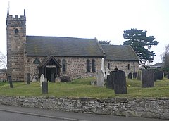
Willington, Derbyshire
| Willington | |
|---|---|
 St Michael's parish church |
|
| Willington shown within Derbyshire | |
| Population | 2,604 (2001 census) |
| OS grid reference | SK2928 |
| Civil parish |
|
| District | |
| Shire county | |
| Region | |
| Country | England |
| Sovereign state | United Kingdom |
| Post town | Derby |
| Postcode district | DE65 |
| Dialling code | 01283 |
| Police | Derbyshire |
| Fire | Derbyshire |
| Ambulance | East Midlands |
| EU Parliament | East Midlands |
| UK Parliament | |
| Website | Willington Parish Council |
Willington is a village and civil parish in the South Derbyshire district of Derbyshire, England. The 2001 Census recorded a parish population of 2,604, increasing to 2,864 at the 2011 Census.
Willington is on the River Trent about 6 miles (10 km) southwest of Derby. The parish is within 0.5 miles (800 m) of the Staffordshire county boundary and the village is about 5 miles (8 km) northeast of Burton upon Trent.
The village is at the crossroads of the north–south B5008 road (for Findern, Repton and Winshill), and the east–west A5132 road (formerly the B5009, linking Hilton and Swarkestone). The A5132 carried a lot of Nottingham – Stoke-on-Trent traffic before the A50 road was opened in September 1997.
The toponym Willington is derived from the Old English tun (homestead or farm) among the willows. In the Domesday Book, the village is called Willetune or Willentune, and the land was held by Ralph FitzHubert and was an agricultural village on the flood plain of the Trent. The village is recorded as Wilintun in about 1150 and as Wyliton in 1230.
Willington, in the hundred of Morleston and Litchurch, comprised two estates as recorded in the Domesday Book of 1086, one held by the king in demesne, the other by Ralph FitzHubert:
...
Wikipedia

