Willapa Bay
| Willapa Bay | |
|---|---|

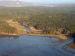
Bone River flows into Willapa Bay's east side
|
|
| Location | Pacific Ocean |
| Coordinates | 46°39′44″N 124°0′38″W / 46.66222°N 124.01056°WCoordinates: 46°39′44″N 124°0′38″W / 46.66222°N 124.01056°W |
| River sources | Bone River, Niawiakum River, Palix River, Naselle River, Bear River |
| Ocean/sea sources | Pacific Ocean |
| Basin countries | United States |
Willapa Bay (/ˈwɪləpɑː/) is a bay located on the southwest Pacific coast of Washington state in the United States. The Long Beach Peninsula separates Willapa Bay from the greater expanse of the Pacific Ocean. With over 260 square miles (670 km2) of water surface Willapa Bay is the second largest estuary on the United States Pacific coast. Early settlers called the bay Shoalwater Bay and this name is found on old maps and charts of the region.
Willapa Bay is fairly shallow: more than half of its surface area lies in the intertidal zone, and in fact half of the volume of water inside it enters and leaves with every tide. The bay is an estuary formed when the Long Beach Peninsula, a long sand spit from the Columbia River to the south, partially enclosed the estuaries of several smaller rivers. It is a ria, which formed after the rise in sea level at the end of the last ice age flooded several small river valleys. The North River, Willapa River, and Naselle River provide most of the freshwater input into the bay. Other rivers that empty into Willapa Bay include the Bone River, Niawiakum River, Palix River, Naselle River, and Bear River, among others.
The bay is bordered by several smaller towns and unincorporated communities such as Raymond, South Bend, both on the Willapa River; while Oysterville, Nahcotta, Bay Center and Tokeland are on the bay itself. The bay is entirely located within Pacific County, Washington and is home to a local oyster and seafood processing industry: approximately 9% of all oysters in the U.S. are grown there.
...
Wikipedia
