Wilkins Township, Pennsylvania
| Wilkins Township | |
|---|---|
| Township | |

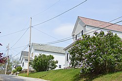
Houses on Beaver Avenue
|
|
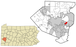
 Location in Allegheny County and state of Pennsylvania |
|
| Coordinates: 40°25′22″N 79°49′25″W / 40.42278°N 79.82361°WCoordinates: 40°25′22″N 79°49′25″W / 40.42278°N 79.82361°W | |
| Country | United States |
| State | Pennsylvania |
| County | Allegheny |
| Area | |
| • Total | 2.6 sq mi (6.8 km2) |
| Population (2010) | |
| • Total | 6,357 |
| • Density | 2,400/sq mi (930/km2) |
| Time zone | Eastern (EST) (UTC-5) |
| • Summer (DST) | EDT (UTC-4) |
| ZIP codes | 15145, 15235 |
Wilkins Township is a township in Allegheny County, Pennsylvania, United States. The population was 6,357 at the 2010 census. It is served by Pennsylvania's 18th congressional district, the 43rd District of the Pennsylvania State Senate, and the 34th District of the Pennsylvania State House of Representatives.
Wilkins Township was named for William Wilkins (1779–1865), a politician from Pennsylvania who served in both houses of Congress and as U.S. Secretary of War.
Wilkins Township is located at 40°25′21″N 79°49′24″W / 40.42250°N 79.82333°W (40.422668, -79.823491). It is bounded to the north by Penn Hills, to the east by Monroeville, PA, to the south by Turtle Creek, PA, and to the west by Chalfant, PA and Churchill, PA.
According to the United States Census Bureau, the township has a total area of 2.6 square miles (6.8 km²), all of it land.
...
Wikipedia
