Wilburton Number One, Pennsylvania
| Wilburton Number One | |
|---|---|
| Census-designated place | |

Wilburton Number One fire company building
|
|
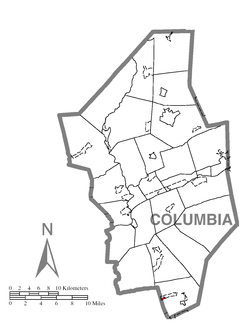
 Location within Columbia County |
|
| Location within the state of Pennsylvania | |
| Coordinates: 40°48′48″N 76°23′26″W / 40.81333°N 76.39056°WCoordinates: 40°48′48″N 76°23′26″W / 40.81333°N 76.39056°W | |
| Country | United States |
| State | Pennsylvania |
| County | Columbia |
| Township | Conyngham |
| Area | |
| • Total | 0.11 sq mi (0.28 km2) |
| • Land | 0.11 sq mi (0.28 km2) |
| • Water | 0.0 sq mi (0.0 km2) |
| Elevation | 1,540 ft (470 m) |
| Population (2010) | |
| • Total | 196 |
| • Density | 1,845/sq mi (712.5/km2) |
| Time zone | Eastern (EST) (UTC-5) |
| • Summer (DST) | EDT (UTC-4) |
| FIPS code | 42-85076 |
| GNIS feature ID | 1191389 |
Wilburton Number One is a census-designated place (CDP) in Columbia County, Pennsylvania, United States. The population was 196 at the 2010 census. It is part of the Bloomsburg–Berwick Micropolitan Statistical Area.
Wilburton Number One is located in southern Columbia County at 40°48′48″N 76°23′26″W / 40.81333°N 76.39056°W (40.813200, -76.390439), on the western end of Conyngham Township. It is bordered to the west by Mount Carmel Township in Northumberland County, to the south by Midvalley Highway, and to the north and east by the Wilburton Number Two CDP. According to the United States Census Bureau, the Wilburton Number One CDP has a total area of 0.12 square miles (0.3 km2), all of it land.
Wilburton Number One and Two are both served by the Wilburton Hose Co. #1. The firehouse is located in Wilburton Number One.
Wilburton Number One is on the top of a mountain, at an elevation of 1,540 feet (470 m). Wilburton Number One's land is a mixture of forest and residential.
...
Wikipedia

