Wiesbaden-Frauenstein
| Frauenstein | ||
|---|---|---|
| Borough of Wiesbaden | ||
 |
||
|
||
| Coordinates: 50°3′54″N 8°9′14″E / 50.06500°N 8.15389°ECoordinates: 50°3′54″N 8°9′14″E / 50.06500°N 8.15389°E | ||
| Country | Germany | |
| State | Hesse | |
| District | Urban district | |
| City | Wiesbaden | |
| Government | ||
| • Director of Borough | Adolf Lupp (SPD) | |
| Area | ||
| • Total | 10.65 km2 (4.11 sq mi) | |
| Population (30.06.2008) | ||
| • Total | 2,365 | |
| • Density | 220/km2 (580/sq mi) | |
| Time zone | CET/CEST (UTC+1/+2) | |
| Postal codes | 65201 | |
| Dialling codes | 0611 | |
| Vehicle registration | WI | |
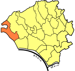
Frauenstein is the western-most borough of the city of Wiesbaden, located in the Rhine Main Area near Frankfurt and capital of the federal state of Hesse, Germany. The borough has a population of approximately 2,400. The formerly independent village was incorporated into Wiesbaden in 1928.
The historic village center is located in the south of the borough. In the center of it are the ruins of a medieval castle, of which the keep still stands. Known as the "Gateway to the Rheingau", the historic village is surrounded by vineyards and fruit orchards. Around late April and early May, its blooming cherry trees make Frauenstein a popular destination.
Frauenstein borders the Wiesbaden boroughs of Dotzheim to the north and northeast and Schierstein to the southeast. The town of Schlangenbad lies to the west. The Schlangenbad borough of Georgenborn is almost an enclave, bordered to the north, east, and south by Frauenstein.
The historic village center of Frauenstein is situated in a narrow valley formed by two streams, the Lippbach and Katzbach. These are joined by the Erlenbach south of the village center to form the Grorother Bach. The Grorother Bach flows southeast, reaching the Rhine at Schierstein.
A hill called the Spitzen Stein stands just east of the village center. Other nearby high points include Grauerstein (elevation 339 m) to the northwest and Leierkopf (207 m) to the east. The highest point in Frauenstein is Rotekrauzkopf (elevation 509 m) in the far northwest of the borough. The Frauenstein area is home to a population of the Aesculapian Snake, a large, non-venomous snake rare to this area of Europe.
While the German name Frauen-Stein can be translated "women's stone", it actually derives from Vrowenstein, a name which first appears in the historical record in 1221. In that year, a deed names a Heinrich Bodo von Vrowenstein (in 1207/1209, he was mentioned as being from Idstein) as a lord of Frauenstein Castle. In the year 1231, a document of the Erbach monastery mentions a knight by the name of Siegfried von Frauenstein who was a marshal with the bishopric of Mainz. He was a descendant of an aristocratic Schierstein family (which would become extinct in 1380).
...
Wikipedia


