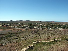
Wickham, Western Australia
|
Wickham Western Australia |
|||||||||
|---|---|---|---|---|---|---|---|---|---|

Wickham townsite
|
|||||||||
| Coordinates | 20°41′00″S 117°08′00″E / 20.68333°S 117.13333°ECoordinates: 20°41′00″S 117°08′00″E / 20.68333°S 117.13333°E | ||||||||
| Population | 1,825 (2006 census) | ||||||||
| Established | 1970s | ||||||||
| Postcode(s) | 6720 | ||||||||
| Location | 33 km (21 mi) from Karratha | ||||||||
| LGA(s) | City of Karratha | ||||||||
| State electorate(s) | North West | ||||||||
| Federal Division(s) | Durack | ||||||||
|
|||||||||
Wickham is a townsite located 1,572 km north of Perth and 13 km north of Roebourne in the Pilbara region of Western Australia.
The town's first permanent buildings were begun in 1970 by Cliffs Robe River to support its iron-ore mine at Pannawonica, processing at Cape Lambert and shiploading at Port Walcott. The majority of the residences and facilities in town are owned by Rio Tinto. Wickham was originally a closed company town but was transferred to administration by the Shire of Roebourne in 1980, after which a scheme for public housing was implemented. Wickham now has an estimated population of 1,800 people.
It has a close nexus with Cossack, Roebourne and Karratha. Wickham was established in 1970 by Cliffs Robe River Iron Associates (Robe) and named after John Clements Wickham, the captain of HMS Beagle, who surveyed the north-west coast in 1840. Robe’s aim was to create a processing plant for the iron ore mined at nearby Pannawonica, a port (at Cape Lambert) from which to ship the produce, and a town to house the associated employees.
Just out of Wickham, the Cape Lambert Iron Ore ship loading facility boasts one of the longest and tallest jetties in Australia. View the massive 170 tonne haul truck at Robe's Visitor Centre. At sunset visit Wickham's Tank Hill lookout for sweeping views, or walk the secluded pristine sandy beaches around Port Walcott, home of the local yacht club.
...
Wikipedia

