Whixall
| Whixall | |
|---|---|
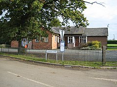
 Whixall Community Centre |
|
| Whixall shown within Shropshire | |
| Population | 795 (2011) |
| OS grid reference | SJ516344 |
| Civil parish |
|
| Unitary authority | |
| Ceremonial county | |
| Region | |
| Country | England |
| Sovereign state | United Kingdom |
| Post town | Whitchurch |
| Postcode district | SY13 |
| Dialling code | 01948 |
| Police | West Mercia |
| Fire | Shropshire |
| Ambulance | West Midlands |
| EU Parliament | West Midlands |
| UK Parliament | |
Whixall is a small and rural village and civil parish in Shropshire, England, which is documented in the Domesday Book as having been in existence in 1086.
The nearest towns are Whitchurch, to the north, and Wem, to the south.
The parish lies on the border with the county borough of Wrexham, Wales. Its close proximity to Wales is shown by a hamlet called Welsh End.
Within the parish boundaries (encompassing seven square miles) are various hamlets including Abbey Green. The Llangollen Canal of the Shropshire Union Canal, as well as the short Prees Branch of the Ellesmere Canal, run through the parish.
Prees was the intended destination of the Prees Branch, however the arm was only completed as far as Quina Brook. The arm is now known as the Prees Branch of the Llangollen Canal, and is navigavable for about a mile to Whixall Marina, the following 3/4 mile is still followable on the towpath as it passes through Prees Branch Canal Nature Reserve. The canal is crossed by Dobson's Bridge, a fixed humpback bridge, was classified in 1987 as a Grade Il listed building.
Adjacent to Whixall is Whixall Moss, part of Fenn's, Whixall and Bettisfield Mosses National Nature Reserve, the third largest lowland raised bog in Britain, a rare habitat and the home of a number of rare species.
...
Wikipedia

