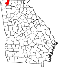
Whitfield County, Georgia
| Whitfield County, Georgia | |
|---|---|
 Location in the U.S. state of Georgia |
|
 Georgia's location in the U.S. |
|
| Founded | December 30, 1851 |
| Seat | Dalton |
| Largest city | Dalton |
| Area | |
| • Total | 291 sq mi (754 km2) |
| • Land | 290 sq mi (751 km2) |
| • Water | 0.6 sq mi (2 km2), 0.2% |
| Population | |
| • (2010) | 102,599 |
| • Density | 353/sq mi (136/km²) |
| Congressional district | 14th |
| Time zone | Eastern: UTC-5/-4 |
| Website | www |
Whitfield County is a county located in the northwestern part of the U.S. state of Georgia. As of the 2010 census shows a population of 102,599. The county seat is Dalton. The county was created on December 30, 1851.
Whitfield County is part of the Dalton, Georgia Metropolitan Statistical Area, which is also included in the Chattanooga-Cleveland-Dalton, TN-GA-AL Combined Statistical Area.
During the Civil War, the men of Whitfield County answered the call to enlist in the Confederate Army. The following units were raised in Whitfield County.
Several engagements took place in and around Whitfield County including:
According to the U.S. Census Bureau, the county has a total area of 291 square miles (750 km2), of which 290 square miles (750 km2) is land and 0.6 square miles (1.6 km2) (0.2%) is water. The majority of Whitfield County is located in the Conasauga River sub-basin in the ACT River Basin (Coosa-Tallapoosa River Basin), with a part of the western edge of the county is located in the Middle Tennessee-Chickamauga sub-basin of the Middle Tennessee-Hiwassee basin. A very small portion of the southern edge of the county is located in the Oostanaula River sub-basin in the larger ACT River Basin.
...
Wikipedia
