Whitewater, California
| Whitewater | |
|---|---|
| census-designated place | |

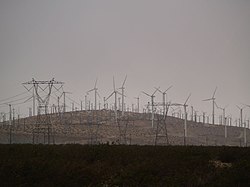
Wind turbines and power lines in Whitewater, California
|
|
| Location within the state of California | |
| Coordinates: 33°56′08″N 116°41′14″W / 33.93556°N 116.68722°WCoordinates: 33°56′08″N 116°41′14″W / 33.93556°N 116.68722°W | |
| Country |
|
| State |
|
| County | Riverside |
| Area | |
| • Total | 9.872 sq mi (25.569 km2) |
| • Land | 9.872 sq mi (25.569 km2) |
| • Water | 0 sq mi (0 km2) 0% |
| Elevation | 1,575 ft (480 m) |
| Population (2010) | |
| • Total | 859 |
| • Density | 87/sq mi (34/km2) |
| Time zone | Pacific (PST) (UTC-8) |
| • Summer (DST) | PDT (UTC-7) |
| ZIP codes | 92282 |
| Area code(s) | 760 |
| GNIS feature ID | 2583184 |
Whitewater (formerly, White Water) is a census-designated place in Riverside County, California. It is directly off Interstate 10 halfway between North Palm Springs and Cabazon on the way from Palm Springs to Los Angeles. It is known as the site of the San Gorgonio Pass Wind Farm. The ZIP Code is 92282, and the community is inside area code 760. The population was 859 at the 2010 census. The elevation is 1,575 feet (480 m).
Whitewater is famous for its recently renovated trout farm in the canyon of the Whitewater River.
White Water, still a populated place on the west bank of the Whitewater River, 10 miles (16 km) northwest of Palm Springs.33°54′52″N 116°42′38″W / 33.91444°N 116.71056°W It began as rest and watering place for travelers on the Bradshaw Trail between San Bernardino and La Paz Arizona Territory in 1862. With the start of the Colorado River Gold Rush the trail was created to ship goods and allow people to cross the desert to the new boom towns on the Colorado River and the interior of Arizona Territory. White Water got its name from the White Water Station a stagecoach station that was located there on the Bradshaw Trail. The settlement at White Water remained as a stop on the road into the Coachella Valley and to other desert regions to the east as it does today.
...
Wikipedia

