Whitestone, Virginia
| White Stone, Virginia | |
|---|---|
| Town | |

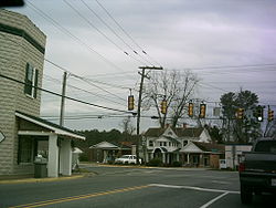
Central White Stone
|
|
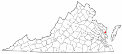
 Location of White Stone, Virginia |
|
| Coordinates: 37°38′43″N 76°23′28″W / 37.64528°N 76.39111°WCoordinates: 37°38′43″N 76°23′28″W / 37.64528°N 76.39111°W | |
| Country | United States |
| State | Virginia |
| County | Lancaster |
| Area | |
| • Total | 1.0 sq mi (2.6 km2) |
| • Land | 1.0 sq mi (2.6 km2) |
| • Water | 0.0 sq mi (0.0 km2) |
| Elevation | 49 ft (15 m) |
| Population (2010) | |
| • Total | 352 |
| Time zone | Eastern (EST) (UTC-5) |
| • Summer (DST) | EDT (UTC-4) |
| ZIP code | 22578 |
| Area code(s) | 804 |
| FIPS code | 51-85600 |
| GNIS feature ID | 1476645 |
White Stone is a town in Lancaster County, Virginia, United States. The population was 352 at the 2010 census. The name "White Stone" refers to the accumulations of white stones in the area's waterways. The stones were dumped there in the colonial era by British ships that dumped their stone ballast to make room for cargo like tobacco to carry back to England.
Pop Castle was listed on the National Register of Historic Places in 1989.
White Stone is located at 37°38′43″N 76°23′28″W / 37.64528°N 76.39111°W (37.645182, -76.391242).
According to the United States Census Bureau, the town has a total area of 1.0 square miles (2.6 km²), all of it land.
As of the census of 2000, there were 358 people, 163 households, and 101 families residing in the town. The population density was 362.1 people per square mile (139.6/km²). There were 187 housing units at an average density of 189.2 per square mile (72.9/km²). The racial makeup of the town was 86.31% White, 10.34% African American, 2.23% Asian, 0.28% from other races, and 0.84% from two or more races. Hispanic or Latino of any race were 0.84% of the population.
...
Wikipedia
