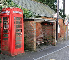
Whiteparish
| Whiteparish | |
|---|---|
 Bus shelter, Whiteparish |
|
| Whiteparish shown within Wiltshire | |
| Population | 1,504 (in 2011) |
| OS grid reference | SU246236 |
| Civil parish |
|
| Unitary authority | |
| Ceremonial county | |
| Region | |
| Country | England |
| Sovereign state | United Kingdom |
| Post town | Salisbury |
| Postcode district | SP5 |
| Dialling code | 01794 |
| Police | Wiltshire |
| Fire | Dorset and Wiltshire |
| Ambulance | South Western |
| EU Parliament | South West England |
| UK Parliament | |
| Website | Whiteparish |
Whiteparish is a village and civil parish on the A27 about 7.5 miles (12.1 km) southeast of Salisbury in Wiltshire, England. The village is about 1.5 miles (2.4 km) from the county boundary with Hampshire. The parish includes the hamlets of Cowesfield Green (east of Whiteparish on the A27) and Newton (southwest, near the A36).
Cowesfield was recorded in the Domesday Book of 1086, together with nearby settlements at Alderstone (now extinct) and Frustfield (which became Whiteparish).
The place-name 'Whiteparish' is first attested in 1319. It was earlier recorded as 'la Whytechyrche' in 1278, and 'Album Monasterium' in 1291, which both mean 'white church'. The reference is presumably to a stone or whitewashed church.
The civil parish elects a parish council. It is in the area of Wiltshire Council unitary authority, which is responsible for all significant local government functions.
The parish falls in 'Alderbury and Whiteparish' electoral ward. The ward starts in the northwest at Alderbury and stretches south east to Whiteparish. The ward population taken at the 2011 census was 4,261.
The Church of England parish church of All Saints is Grade II* listed. It has 12th-century origins and was restored by William Butterfield in 1870. A painting St Peter denying Christ is by J F Rigaud.
...
Wikipedia

