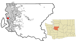
White Center, Washington
| White Center, Washington | |
|---|---|
| CDP | |
 Location of White Center, Washington |
|
| Coordinates: 47°30′27″N 122°20′51″W / 47.50750°N 122.34750°WCoordinates: 47°30′27″N 122°20′51″W / 47.50750°N 122.34750°W | |
| Country | United States |
| State | Washington |
| County | King |
| Area | |
| • Total | 2.25 sq mi (5.83 km2) |
| • Land | 2.24 sq mi (5.81 km2) |
| • Water | 0.01 sq mi (0.02 km2) |
| Elevation | 381 ft (116 m) |
| Population (2010) | |
| • Total | 13,495 |
| • Density | 5,996.0/sq mi (2,315.1/km2) |
| Time zone | Pacific (PST) (UTC-8) |
| • Summer (DST) | PDT (UTC-7) |
| ZIP codes | 98106, 98146, 98168 |
| Area code(s) | 206 |
| FIPS code | 53-78225 |
| GNIS feature ID | 1512801 |
White Center is a census-designated place (CDP) in West Seattle, King County, Washington, United States. It lies between West Seattle and Burien. The population was 13,495 at the 2010 census.
White Center is sometimes referred to by the nickname "Rat City" due to the historical presence of a military Relocation and Training Center during World War II. The Rat City Rollergirls are a Seattle roller derby team that began training in White Center.
White Center is located at 47°30′27″N 122°20′51″W / 47.50750°N 122.34750°W (47.507370, -122.347385). It has a total area of 2.25 square miles (5.83 km²), of which 99.6% is land and 0.4% is water.
As of the census of 2010, there were 13,495 people, 4,920 households, and 3,105 families residing in the CDP. The population density was 5,996.0 people per square mile (2,315.1/km²). There were 5,235 housing units at an average density of 2,326.0/sq mi (898.1/km²). The racial makeup of the CDP was 47.0% White (39.6% Non-Hispanic White), 9.0% Black or African American, 1.6% American Indian and Alaska Native, 22.9% Asian, 1.7% Native Hawaiian and Other Pacific Islander, 11.4% from other races, and 6.4% from two or more races. Hispanic or Latino people of any race were 21.5% of the population.
...
Wikipedia
