Wheaton, Minnesota
| Wheaton, Minnesota | |
|---|---|
| City | |
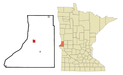
 Location of Wheaton within Traverse County, Minnesota |
|
| Coordinates: 45°48′17″N 96°29′46″W / 45.80472°N 96.49611°W | |
| Country | United States |
| State | Minnesota |
| County | Traverse |
| Area | |
| • Total | 1.80 sq mi (4.66 km2) |
| • Land | 1.80 sq mi (4.66 km2) |
| • Water | 0 sq mi (0 km2) |
| Elevation | 1,020 ft (311 m) |
| Population (2010) | |
| • Total | 1,424 |
| • Estimate (2013) | 1,377 |
| • Density | 791.1/sq mi (305.4/km2) |
| Time zone | Central (CST) (UTC-6) |
| • Summer (DST) | CDT (UTC-5) |
| ZIP code | 56296 |
| Area code(s) | 320 |
| FIPS code | 27-69844 |
| GNIS feature ID | 0654055 |
| Website | City of Wheaton |
Wheaton is a city in Traverse County, Minnesota, United States. The population was 1,424 at the 2010 census. It is the county seat.
A post office called Wheaton has been in operation since 1884. Wheaton was designated county seat in 1886. The city was named for Daniel Thompson Wheaton, a railroad surveyor. One property in the city is listed on the National Register of Historic Places: the Wheaton Depot built circa 1906.
Wheaton lies along the Mustinka River. According to the United States Census Bureau, the city has a total area of 1.80 square miles (4.66 km2), all of it land.
U.S. Highway 75 and Minnesota State Highway 27 are two of the main routes in the city.
As of the census of 2010, there were 1,424 people, 655 households, and 370 families residing in the city. The population density was 791.1 inhabitants per square mile (305.4/km2). There were 834 housing units at an average density of 463.3 per square mile (178.9/km2). The racial makeup of the city was 97.4% White, 0.6% African American, 0.7% Native American, 0.1% Asian, 0.1% Pacific Islander, 0.2% from other races, and 1.0% from two or more races. Hispanic or Latino of any race were 1.5% of the population.
...
Wikipedia
