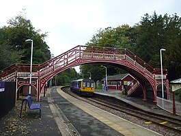
Wetheral railway station
| Wetheral |
|
|---|---|

Wetheral Station
|
|
| Location | |
| Place | Wetheral |
| Local authority | Carlisle |
| Grid reference | NY467546 |
| Operations | |
| Station code | WRL |
| Managed by | Northern |
| Number of platforms | 2 |
| DfT category | F2 |
| Live arrivals/departures, station information and onward connections from National Rail Enquiries |
|
| Annual rail passenger usage* | |
| 2011/12 |
|
| 2012/13 |
|
| 2013/14 |
|
| 2014/15 |
|
| 2015/16 |
|
| History | |
| Key dates | Opened 1981 |
| National Rail – UK railway stations | |
| * Annual estimated passenger usage based on sales of tickets in stated financial year(s) which end or originate at Wetheral from Office of Rail and Road statistics. Methodology may vary year on year. | |
|
|
|
Wetheral railway station is on the Newcastle-Carlisle Tyne Valley Line in northern England, situated some seven minutes from Carlisle. The station serves Wetheral and Great Corby.
Passenger services are provided by Northern.
Access to the station is by a dead-end road from Wetheral village green, or by a footpath from the B6263 opposite Plains Road. A footbridge links the two platforms. Corby Bridge (popularly known as 'Wetheral Viaduct'), over which trains pass when leaving the station towards Newcastle, has a footpath that links the station with the nearby village of Great Corby.
The station has ten trains stopping in each direction on weekdays, with a reduced service on Sundays. Other faster passenger trains and goods trains pass through without stopping. Trains that stop at Wetheral also stop at all other stations west of Hexham on the Tyne Valley line. Passengers for stations between Hexham and Newcastle usually have to change at Hexham.
The station was originally staffed, and the old stationmaster's house still stands, as a private residence. The boarded up ticket windows are still visible. The station was closed during the Beeching cuts (in 1967) but reopened by British Rail in January 1981.
The station is unstaffed and has no ticket facilities - all tickets must be bought prior to travel or on the train. Train running information is provided via timetable posters or by telephone (there is a payphone on platform 2). Shelters are located on each platform and there is level access to the eastbound platform only (the westbound equivalent can only be reached via the footbridge, which does not have ramps).
Coordinates: 54°53′02″N 2°49′55″W / 54.884°N 2.832°W
...
Wikipedia
