Westonzoyland Pumping Station Museum
| Westonzoyland Pumping Station Museum of Steam Power & Land Drainage | |
|---|---|

Westonzoyland Pumping Station Museum
|
|
|
Location within Somerset
|
|
| General information | |
| Town or city | Westonzoyland |
| Country | England |
| Coordinates | 51°05′27″N 2°56′40″W / 51.090928°N 2.944328°W |
| Completed | 1861 |
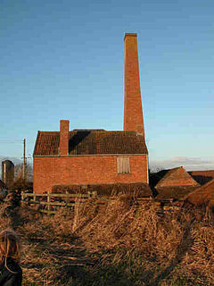
The Westonzoyland Pumping Station Museum of Steam Power and Land Drainage is a small industrial heritage museum dedicated to steam powered machinery at Westonzoyland in the English county of Somerset. It is a Grade II* listed building.
The museum is housed in a 1830 brick-built pumping station which was the first of several similar pumping stations to be built on the Somerset Levels which are prone to flooding. The main attraction is the 1861 Easton and Amos steam engine and pump, the only one still in its original location and in working order. The museum, which is run by a charity, also restores and displays a number of other steam engines and pumps. The steam for the moving exhibits is provided by a Marshall portable boiler. The Westonzoyland Light Railway, a short 2 ft (610 mm) narrow-gauge railway runs the length of the site and is used to carry wood for the boiler.
The Somerset Moors and Levels, formed from a submerged and reclaimed landscape, consist of a coastal clay belt only slightly above mean sea level, with an inland peat belt at a lower level behind it. Early attempts to control the water levels were possibly made by the Romans (although records only date from the 13th century), but were not widespread. The Domesday Book of 1086 recorded that drainage of the higher grounds was under way. In the Middle Ages, the monasteries of Glastonbury, Athelney and Muchelney were responsible for much of the drainage. Efforts to control flooding on the Parrett were recorded around 1129. In 1234, 722 acres (2.9 km2) were reclaimed near Westonzoyland and, from the accounts in Glastonbury Abbey's rent books, this had increased to 972 acres (393 ha) by 1240. Flooding of adjacent moor land was partially addressed during the 13th century by the construction of a number of embankment walls to contain the Parrett. They included Southlake Wall, Burrow Wall and Lake Wall. The River Tone was diverted by the Abbot of Athelney and other land owners into a new embanked channel, joining the Parrett upstream from its original confluence.
...
Wikipedia

