Weston County, Wyoming
| Weston County, Wyoming | |
|---|---|

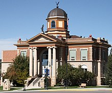
Weston County Courthouse in Newcastle
|
|
 Location in the U.S. state of Wyoming |
|
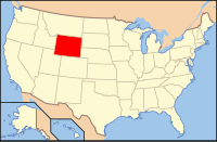
 Wyoming's location in the U.S. |
|
| Founded | 1890 |
| Seat | Newcastle |
| Largest city | Newcastle |
| Area | |
| • Total | 2,400 sq mi (6,216 km2) |
| • Land | 2,398 sq mi (6,211 km2) |
| • Water | 1.9 sq mi (5 km2), 0.08% |
| Population (est.) | |
| • (2015) | 7,234 |
| • Density | 3.0/sq mi (1/km²) |
| Congressional district | At-large |
| Time zone | Mountain: UTC-7/-6 |
| Website | westongov |
Weston County is a county located in the U.S. state of Wyoming. As of the 2010 census, the population was 7,208. Its county seat is Newcastle. It is west from the South Dakota state line.
Weston County was created by the legislature of the Wyoming Territory on March 12, 1890. The county was created out of a portion of Crook County.
Weston County was named for John B. Weston, who was a geologist and surveyor. In 1887, John Weston and Frank Mondell found rich coal deposits north of Newcastle which caused a railroad to be built through the area.
In 1911, Campbell County was formed from portions of Weston County and Crook County. Since then, the boundaries of Weston County have been stable.
According to the U.S. Census Bureau, the county has a total area of 2,400 square miles (6,200 km2), of which 2,398 square miles (6,210 km2) is land and 1.9 square miles (4.9 km2) (0.08%) is water.
As of the census of 2000, there were 6,644 people, 2,624 households, and 1,868 families residing in the county. The population density was 3 people per square mile (1/km²). There were 3,231 housing units at an average density of 1 per square mile (1/km²). The racial makeup of the county was 95.94% White, 0.12% Black or African American, 1.26% Native American, 0.20% Asian, 0.02% Pacific Islander, 0.93% from other races, and 1.54% from two or more races. 2.06% of the population were Hispanic or Latino of any race. 33.0% were of German, 13.0% English, 8.9% Irish and 7.2% American ancestry.
...
Wikipedia
