Westmount, Saskatoon
| Westmount | |
|---|---|
| Neighbourhood | |

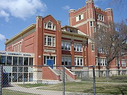
Westmount School
Courtesy of the Westmount Community Association |
|
 Westmount location map |
|
| Coordinates: 52°07′57″N 106°41′11″W / 52.13250°N 106.68639°WCoordinates: 52°07′57″N 106°41′11″W / 52.13250°N 106.68639°W | |
| Country |
|
| Province |
|
| City | Saskatoon |
| Suburban Development Area | Core Neighbourhoods |
| Neighbourhood | Westmount |
| Settled | 1884 |
| Incorporated (as Saskatoon) | 1906 |
| Construction | 1906–1960 |
| Government | |
| • Type | Municipal (Ward 2) |
| • Administrative body | Saskatoon City Council |
| • Councillor | Hilary Gough |
| Area | |
| • Total | 1.72 km2 (0.66 sq mi) |
| Population (2009) | |
| • Total | 2,232 |
| • Density | 1,300/km2 (3,400/sq mi) |
| • Average Income | $44,729 |
| Time zone | CST (UTC-6) |
| Website | westmountcommunity.net |
| Westmount Community School | |
|---|---|
 |
|
| Location | |
|
411 Avenue J North Saskatoon, Saskatchewan, S7L 2K4 Canada |
|
| Information | |
| Type | Elementary |
| Opened | 1913 |
| School board | Saskatoon Public Schools |
| Principal | Angela Caron |
| Vice Principal | Candace Ahmed |
| Grades | Kindergarten to Grade 8 |
| Enrollment | 226 (2016) |
| Education system | Public |
| Language | English |
| Feeder to | Bedford Road Collegiate |
| Website | Westmount Community School |
Westmount is an older inner city neighbourhood located near the centre of Saskatoon, Saskatchewan, Canada. It mostly consists of low-density, single detached dwellings. As of 2009, the area is home to 2,232 residents. The neighbourhood is considered a lower-income area, with an average family income of $44,729, an average dwelling value of $162,491 and a home ownership rate of 68.9%. According to MLS data, the average sale price of a home as of 2013 was $207,347.
The area that now makes up Westmount was settled by homesteaders in 1884, as the east bank settlement of Saskatoon struggled for survival. A settler named Archibald L. Brown was one such landowner, owning a section of land where Westmount School would later be built. The neighbourhood was within the city limits when the City of Saskatoon incorporated in 1906. At that time it was the city's northwest corner, hence the name. The streets in Westmount are named for early settlers of the Saskatoon area, and most of the houses were built prior to 1960.
The neighbourhood appeared on a surveyors' map in 1911. The current boundaries of Westmount include some of an area called Ruskin Place, which appears on a 1913 map of registered subdivisions.
Westmount School was opened on April 3, 1913. It was designed by architect David Webster, who designed six of Saskatoon's Collegiate Gothic style elementary schools between 1910 and 1914. E.D. Feehan High School was opened in 1967, and named in honour of Edward Daniel Feehan, a former superintendent of separate schools in Saskatoon. It is designated a bilingual English and Ukrainian school, and also has classes in Cree and Spanish.
McMillan Avenue, which forms part of Westmount's western boundary, is named for Frank MacMillan. He was a Toronto businessman who moved to Saskatoon, owned several successful businesses, and built several landmark buildings downtown. He would serve as Saskatoon's mayor and later a Member of Parliament.
Development prior to 1927 was haphazard, which sometimes resulted in irregularity between neighbourhood streets between Westmount and Caswell Hill. In 1927, the first formal town planning board was established. Westmount was zoned Residence A District, which limited development to one and two-family houses of no more than two-and-a-half storeys.
In its recent history, Westmount has become a lower-income inner city neighbourhood. It and other core neighbourhoods have been the recipients of affordable housing and community economic development initiatives to improve the lives of residents.
...
Wikipedia
