Westhampton, Massachusetts
| Westhampton, Massachusetts | ||
|---|---|---|
| Town | ||

Westhampton Town Hall
|
||
|
||
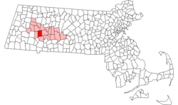
 Location in Hampshire County in Massachusetts |
||
| Coordinates: 42°18′10″N 72°46′30″W / 42.30278°N 72.77500°WCoordinates: 42°18′10″N 72°46′30″W / 42.30278°N 72.77500°W | ||
| Country | United States | |
| State | Massachusetts | |
| County | Hampshire | |
| Settled | 1762 | |
| Incorporated | 1778 | |
| Government | ||
| • Type | Open town meeting | |
| Area | ||
| • Total | 27.3 sq mi (70.8 km2) | |
| • Land | 27.1 sq mi (70.3 km2) | |
| • Water | 0.2 sq mi (0.5 km2) | |
| Elevation | 730 ft (223 m) | |
| Population (2000) | ||
| • Total | 1,468 | |
| • Density | 54.1/sq mi (20.9/km2) | |
| Time zone | Eastern (UTC-5) | |
| • Summer (DST) | Eastern (UTC-4) | |
| ZIP code | 01027 | |
| Area code(s) | 413 | |
| FIPS code | 25-76380 | |
| GNIS feature ID | 0618210 | |
Westhampton is a town in Hampshire County, Massachusetts, United States. The population was 1,607 at the 2010 census. It is part of the Springfield, Massachusetts Metropolitan Statistical Area.
Westhampton was first settled in 1762. Originally part of Northampton, Westhampton was officially incorporated on September 29, 1778. The first town meeting was held on November 19, 1778, at which the Reverend Enoch Hale, brother of American spy Nathan Hale, was chosen to be the town's first minister Westhampton is one of 8 "dry" towns in the Commonwealth, meaning that the sale of alcoholic beverages is prohibited within its boundaries.
The town is home to the five-town Hampshire Regional High School.
According to the United States Census Bureau the town has a total area of 27.3 square miles (70.7 km2), of which 27.1 square miles (70.2 km2) is land and 0.2 square miles (0.5 km2) is water. Westhampton is bordered by Southampton to the south, Huntington to the west, Chesterfield to the northwest, Williamsburg to the northeast, Northampton to the east, and Easthampton to the southeast.
As of the census of 2000, there were 1,468 people, 542 households, and 422 families residing in the town. The population density was 54.1 people per square mile (20.9/km²). There were 623 housing units at an average density of 23.0 per square mile (8.9/km²). The racial makeup of the town was 98.50% White, 0.34% Native American, 0.14% Asian, 0.27% from other races, and 0.75% from two or more races. Hispanic or Latino of any race were 0.54% of the population.
...
Wikipedia

