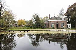
Westerveld (municipality)
| Westerveld | ||
|---|---|---|
| Municipality | ||

Town of Dwingeloo
|
||
|
||
 Location in Drenthe |
||
| Coordinates: 52°52′N 6°19′E / 52.867°N 6.317°ECoordinates: 52°52′N 6°19′E / 52.867°N 6.317°E | ||
| Country | Netherlands | |
| Province | Drenthe | |
| Established | 1 January 1998 | |
| Government | ||
| • Body | Municipal council | |
| • Mayor | Rikus Jager (CDA) | |
| Area | ||
| • Total | 282.74 km2 (109.17 sq mi) | |
| • Land | 278.81 km2 (107.65 sq mi) | |
| • Water | 3.93 km2 (1.52 sq mi) | |
| Elevation | 8 m (26 ft) | |
| Population (February 2017) | ||
| • Total | 18,937 | |
| • Density | 68/km2 (180/sq mi) | |
| Time zone | CET (UTC+1) | |
| • Summer (DST) | CEST (UTC+2) | |
| Postcode | Parts of 7000 and 8000 range | |
| Area code | 0521, 0561 | |
| Website | gemeentewesterveld |
|
Westerveld (![]() pronunciation ) is a municipality in the northeastern Netherlands.
pronunciation ) is a municipality in the northeastern Netherlands.
The municipality Westerveld was established in 1998 out of the municipalities of Diever, Dwingeloo, Havelte, and Vledder. Westerveld is crossed by a channel, the Drentsche Hoofdvaart. There are also two National Parks situated in the municipality, the Drents-Friese Wold and Dwingelerveld.
Boschoord, Darp, Diever, Dieverbrug, Doldersum, Dwingeloo, Eemster, Frederiksoord, Geeuwenbrug, Havelte, Havelterberg, Leggeloo, Lhee, Lheebroek, Nijensleek, Oude Willem, Uffelte, Vledder, Vledderveen, Wapse, Wapserveen, Wateren, Wilhelminaoord, Wittelte and Zorgvlied.
...
Wikipedia
