West Vincent Township, Pennsylvania
| West Vincent Township | |
|---|---|
| Township | |

|
|
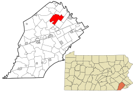
 Location in Chester County and the state of Pennsylvania. |
|
 Location of Pennsylvania in the United States |
|
| Coordinates: 40°07′43″N 75°38′38″W / 40.12861°N 75.64389°WCoordinates: 40°07′43″N 75°38′38″W / 40.12861°N 75.64389°W | |
| Country | United States |
| State | Pennsylvania |
| County | Chester |
| Area | |
| • Total | 17.8 sq mi (46 km2) |
| • Land | 17.8 sq mi (46 km2) |
| • Water | 0.04 sq mi (0.1 km2) |
| Elevation | 325 ft (99 m) |
| Population (2010) | |
| • Total | 4,567 |
| • Estimate (2016) | 5,084 |
| • Density | 256.6/sq mi (99.1/km2) |
| Time zone | EST (UTC-5) |
| • Summer (DST) | EDT (UTC-4) |
| Area code(s) | 610 |
| FIPS code | 42-029-84160 |
West Vincent Township is a township in Chester County, Pennsylvania, United States. The population was 4,567 at the 2010 census.
The Birchrunville General Store, Birchrunville Historic District, Deery Family Homestead, Nicholas East House, French Creek Farm, Robert Rooke House, and Strickland-Roberts Homestead are listed on the National Register of Historic Places.
According to the United States Census Bureau, the township has a total area of 17.8 square miles (46 km2), of which 0.04 square miles (0.10 km2), or 0.22%, is water. West Vincent Township is divided from East Vincent Township by French Creek; these two townships were combined as Vincent Township until 1832. The township is partially located in the Hopewell Big Woods.
An interesting feature of West Vincent Township is its "missing quarter". In 1715, founder Sir Mathias Vincent and others failed to pay taxes to William Penn, who took them to court. In the end, 467 acres (1.89 km2) in southern West Vincent Township were seized and given to Upper Uwchlan Township. This is shown in modern days by Pennsylvania Route 401, which, while travelling straight, leaves this township but soon re-enters it.
...
Wikipedia
