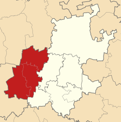
West Rand District Municipality
| West Rand | ||
|---|---|---|
| District municipality | ||
|
||
 Location in Gauteng |
||
| Coordinates: 26°15′S 27°30′E / 26.250°S 27.500°ECoordinates: 26°15′S 27°30′E / 26.250°S 27.500°E | ||
| Country | South Africa | |
| Province | Gauteng | |
| Seat | Randfontein | |
| Local municipalities | ||
| Government | ||
| • Type | Municipal council | |
| • Mayor | Mpho Nawa | |
| Area | ||
| • Total | 4,087 km2 (1,578 sq mi) | |
| Population (2011) | ||
| • Total | 820,995 | |
| • Density | 200/km2 (520/sq mi) | |
| Racial makeup (2011) | ||
| • Black African | 79.2% | |
| • Coloured | 2.5% | |
| • Indian/Asian | 1.1% | |
| • White | 16.7% | |
| First languages (2011) | ||
| • Tswana | 27.3% | |
| • Afrikaans | 16.9% | |
| • Xhosa | 14.9% | |
| • Sotho | 10.8% | |
| • Other | 30.1% | |
| Time zone | SAST (UTC+2) | |
| Municipal code | DC48 | |
West Rand District Municipality is one of the districts of Gauteng province of South Africa, that covers the West Rand area, with the exception of Roodepoort. The seat of the district municipality is Randfontein. The most spoken language of its 744 168 people is Setswana (2001 Census). The district code is CBDC8.
West Rand is surrounded by:
The district contains the following local municipalities:
The following statistics are from the 2011
Election results for West Rand in the South African general election, 2004.
...
Wikipedia

