West Mansfield, Ohio
| West Mansfield, Ohio | |
|---|---|
| Village | |

Aerial view of West Mansfield from the east
|
|
 Location of West Mansfield, Ohio |
|
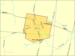
 Detailed map of West Mansfield |
|
| Coordinates: 40°24′2″N 83°32′34″W / 40.40056°N 83.54278°WCoordinates: 40°24′2″N 83°32′34″W / 40.40056°N 83.54278°W | |
| Country | United States |
| State | Ohio |
| Counties | Logan |
| Area | |
| • Total | 0.86 sq mi (2.23 km2) |
| • Land | 0.83 sq mi (2.15 km2) |
| • Water | 0.03 sq mi (0.08 km2) |
| Population (2010) | |
| • Total | 682 |
| • Estimate (2012) | 675 |
| • Density | 821.7/sq mi (317.3/km2) |
| Time zone | Eastern (EST) (UTC-5) |
| • Summer (DST) | EDT (UTC-4) |
| ZIP code | 43358 |
| Area code(s) | 937 |
West Mansfield is a village located in Logan County, Ohio, United States. The population was 682 at the 2010 census.
A branch of the Logan County District Library serves the West Mansfield community.
West Mansfield was laid out in 1848. A post office called West Mansfield has been in operation since 1863.
West Mansfield is located at 40°24′02″N 83°32′34″W / 40.400452°N 83.542652°W.
According to the United States Census Bureau, the village has a total area of 0.86 square miles (2.23 km2), of which, 0.83 square miles (2.15 km2) is land and 0.03 square miles (0.08 km2) is water.
As of the census of 2010, there were 682 people, 271 households, and 190 families residing in the village. The population density was 821.7 inhabitants per square mile (317.3/km2). There were 309 housing units at an average density of 372.3 per square mile (143.7/km2). The racial makeup of the village was 96.6% White, 0.9% African American, 0.1% Native American, 0.1% Asian, and 2.2% from two or more races. Hispanic or Latino of any race were 0.1% of the population.
...
Wikipedia
