West Livingston
| West Livingston, Texas | |
|---|---|
| CDP | |

|
|
 |
|
| Coordinates: 30°42′34″N 95°1′9″W / 30.70944°N 95.01917°WCoordinates: 30°42′34″N 95°1′9″W / 30.70944°N 95.01917°W | |
| Country | United States |
| State | Texas |
| County | Polk |
| Area | |
| • Total | 24.0 sq mi (62.1 km2) |
| • Land | 23.9 sq mi (62.0 km2) |
| • Water | 0.0 sq mi (0.1 km2) |
| Elevation | 141 ft (43 m) |
| Population (2010) | |
| • Total | 8,071 |
| • Density | 340/sq mi (130/km2) |
| Time zone | Central (CST) (UTC-6) |
| • Summer (DST) | CDT (UTC-5) |
| FIPS code | 48-77662 |
| GNIS feature ID | 1852781 |
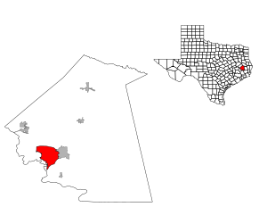
West Livingston is a census-designated place (CDP) in western Polk County, Texas, United States, located along the eastern shore of Lake Livingston 6 miles (9.7 km) west of central Livingston. The population was 8,071 at the 2010 census.
The development in West Livingston began in the late 20th century. The Handbook of Texas stated that the community was "probably" named after its geographic location.
West Livingston is located at 30°42′34″N 95°01′09″W / 30.709430°N 95.019249°W (30.709430, -95.019249).
According to the United States Census Bureau, the CDP has a total area of 24.0 square miles (62 km2), of which, 23.9 square miles (62 km2) of it is land and 0.04 square miles (0.10 km2) of it (0.17%) is water.
West Livingston is located on the southeast shore of Lake Livingston and is north of Lake Livingston State Park. It is south of US Route 190.
As of the census of 2000, there were 6,612 people, 1,494 households, and 1,087 families residing in the CDP. The population density was 276.2 people per square mile (106.6/km2). There were 2,285 housing units at an average density of 95.4/sq mi (36.9/km2). The racial makeup of the CDP was 66.56% White, 29.93% African American, 0.27% Native American, 0.36% Asian, 1.92% from other races, and 0.95% from two or more races. Hispanic or Latino of any race were 14.70% of the population.
...
Wikipedia
