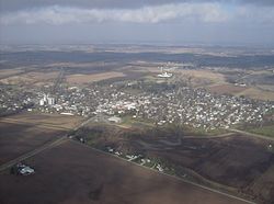
West Liberty, Ohio
| West Liberty, Ohio | |
|---|---|
| Village | |

West Liberty from the southeast
|
|
 Location of West Liberty, Ohio |
|
 Detailed map of West Liberty |
|
| Coordinates: 40°15′15″N 83°45′27″W / 40.25417°N 83.75750°WCoordinates: 40°15′15″N 83°45′27″W / 40.25417°N 83.75750°W | |
| Country | United States |
| State | Ohio |
| Counties | Logan |
| Area | |
| • Total | 1.12 sq mi (2.90 km2) |
| • Land | 1.12 sq mi (2.90 km2) |
| • Water | 0 sq mi (0 km2) |
| Population (2010) | |
| • Total | 1,805 |
| • Estimate (2012) | 1,789 |
| • Density | 1,611.6/sq mi (622.2/km2) |
| Time zone | Eastern (EST) (UTC-5) |
| • Summer (DST) | EDT (UTC-4) |
| ZIP code | 43357 |
| Area code(s) | 937 |
| Website | http://www.mywestliberty.com/ |
West Liberty is a village in Logan County, Ohio, United States. The population was 1,805 at the 2010 census.
West Liberty was laid out in 1817. In 1833, West Liberty contained five stores, two taverns, one tannery, a merchant mill, a saw mill, a carding machine, and about 20 residential houses.
West Liberty is located at 40°15′15″N 83°45′27″W / 40.25417°N 83.75750°W (40.254169, -83.757452).
According to the United States Census Bureau, the village has a total area of 1.12 square miles (2.90 km2), all of it land.
Flowing along the edge of town is the Mad River, a major source of running water in the area.
As of the census of 2010, there were 1,805 people, 736 households, and 436 families residing in the village. The population density was 1,611.6 inhabitants per square mile (622.2/km2). There were 799 housing units at an average density of 713.4 per square mile (275.4/km2). The racial makeup of the village was 96.1% White, 1.3% African American, 0.1% Native American, 0.6% Asian, 0.1% Pacific Islander, 0.2% from other races, and 1.7% from two or more races. Hispanic or Latino of any race were 0.8% of the population.
...
Wikipedia
