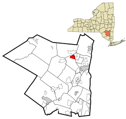
West Hurley, New York
| West Hurley, New York | |
|---|---|
| CDP | |
 Location in Ulster County and the state of New York. |
|
| Coordinates: 42°0′16″N 74°6′34″W / 42.00444°N 74.10944°WCoordinates: 42°0′16″N 74°6′34″W / 42.00444°N 74.10944°W | |
| Country | United States |
| State | New York |
| County | Ulster |
| Area | |
| • Total | 3.8 sq mi (9.8 km2) |
| • Land | 3.8 sq mi (9.8 km2) |
| • Water | 0.0 sq mi (0.0 km2) |
| Elevation | 597 ft (182 m) |
| Population (2010) | |
| • Total | 1,939 |
| Time zone | Eastern (EST) (UTC-5) |
| • Summer (DST) | EDT (UTC-4) |
| ZIP code | 12491 |
| Area code(s) | 845 |
| FIPS code | 36-80291 |
| GNIS feature ID | 0969272 |
West Hurley is a hamlet (and census-designated place) in Ulster County, New York, United States. The population was 1,939 at the 2010 census.
West Hurley is located in the Town of Hurley and is inside the Catskill Park. The community is northwest of Kingston, New York on Route 28.
It was one of many villages that were flooded during the making of the Ashokan Reservoir. The village was moved, and currently resides on the western bank of the reservoir.
West Hurley is located at 42°0′16″N 74°6′34″W / 42.00444°N 74.10944°W (42.004442, -74.109312).
According to the United States Census Bureau, the CDP has a total area of 3.8 square miles (9.8 km2), all land.
As of the census of 2000, there were 2,105 people, 866 households, and 600 families residing in the CDP. The population density was 557.2 per square mile (215.0/km²). There were 954 housing units at an average density of 252.5/sq mi (97.4/km²). The racial makeup of the CDP was 94.54% White, 1.47% African American, 1.76% Asian, 0.10% Pacific Islander, 0.76% from other races, and 1.38% from two or more races. Hispanic or Latino of any race were 2.09% of the population.
...
Wikipedia
