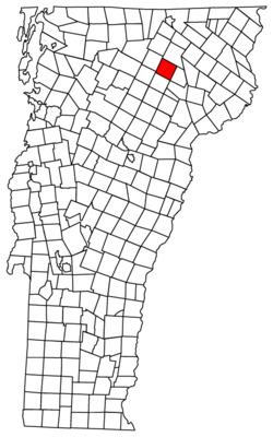
West Glover, Vermont
| Glover, Vermont | |
|---|---|
| Town | |
 Located in Orleans County, Vermont |
|
 Location of Vermont with the U.S.A. |
|
| Coordinates: 44°41′39″N 72°13′16″W / 44.69417°N 72.22111°WCoordinates: 44°41′39″N 72°13′16″W / 44.69417°N 72.22111°W | |
| Country | United States |
| State | Vermont |
| County | Orleans |
| Chartered | November 20, 1783 |
| Area | |
| • Total | 38.6 sq mi (100.0 km2) |
| • Land | 37.9 sq mi (98.1 km2) |
| • Water | 0.7 sq mi (1.9 km2) |
| Elevation | 945 ft (507 m) |
| Population (2000) | |
| • Total | 966 |
| • Density | 25.5/sq mi (9.8/km2) |
| • Households | 384 |
| • Families | 269 |
| Time zone | EST (UTC-5) |
| • Summer (DST) | EDT (UTC-4) |
| ZIP code | 05839 |
| Area code(s) | 802 |
| FIPS code | 50-28075 |
| GNIS feature ID | 1462103 |
Glover is a town in Orleans County, Vermont, in the United States. As of the 2000 census the town's population was 966. It contains two unincorporated villages, Glover and West Glover.
The town is named for Brigadier General John Glover, who served in the American Revolutionary War. He was the prime proprietor of the town.
Glover is home of the Bread & Puppet Museum.
According to the United States Census Bureau, the town has a total area of 38.6 square miles (100.0 km2), of which 37.9 square miles (98.1 km2) is land and 0.7 square mile (1.9 km2) (1.92%) is water.
The surface of the town is uneven, with hills and valleys. The highest elevation is Black Hills, at 2,258 feet (688 m), in the south part of town. The town drains northward via the northern branches of the Barton River, and southward via branches of the Passumpsic, Lamoille, and Black Rivers, which have their sources here. Four ponds of considerable size also are found here, Parker Pond, in the north, Stone's and Clark's pond, in the south and central, and Sweeney pond in the west, as well as Shadow Lake. Shadow Lake was first called Chambers Pond, then Stone Pond about 1822. In 1922 it was given its current name. The Abenaki had called it Pekdabowk, or Smoke Pond.
In 1802, the town decided to construct one school at the Parker settlement. Operating expenses were limited to $20 for that year.
In the most cataclysmic natural catastrophe affecting Orleans County in post-Columbian times, the banks of Glover's Long Pond gave way on June 6, 1810, and flooded the Barton River valley. The hero of the day was laborer Spencer Chamberlain who ran ahead of the flood to warn people at the mill. The wayward pond was forever after known as "Runaway Pond".
By 1851, there were 450 grammar school students. In 2017, the number of students at that level had dropped to about 100.
...
Wikipedia
