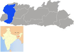
West Garo Hills
|
West Garo Hills district West Garo |
|
|---|---|
| District of Meghalaya | |
 Location of West Garo Hills district in Meghalaya |
|
| Country | India |
| State | Meghalaya |
| Headquarters | Tura, India |
| Government | |
| • Assembly seats | 7 |
| Area | |
| • Total | 3,714 km2 (1,434 sq mi) |
| Population (2001) | |
| • Total | 515,813 |
| • Density | 140/km2 (360/sq mi) |
| Demographics | |
| • Literacy | 53% |
| Website | Official website |
West Garo Hills is an administrative district in Garo Hills of the state of Meghalaya in India. Tura town is the administrative headquarters of the district. The district occupies an area of 3714 km² and has a population of 515,813 (as of 2001). As of 2011 it is the second most populous district of Meghalaya (out of 7), after East Khasi Hills.
West Garo Hills district is located at the westernmost part of Meghalaya. The district is bounded by East Garo Hills district on the east, by South Garo Hills district on the south-east, Goalpara district of Assam state on the north and north-west and Bangladesh on the south.
In 22 October 1976 the erstwhile Garo Hills district was bifurcated into two districts: West Garo Hills district and East Garo Hills district The ersthwile West Garo Hills district was further divided into two districts: the present day West Garo Hills district and South Garo Hills district in June, 1992.
In 2006 the Ministry of Panchayati Raj named West Garo Hills one of the country's 250 most backward districts (out of a total of 640). It is one of the three districts in Meghalaya currently receiving funds from the Backward Regions Grant Fund Programme (BRGF).
West Garo Hills district is divided into six blocks, after the creation of South West Garo Hills district :
...
Wikipedia
