West Feliciana Parish, Louisiana
| West Feliciana Parish, Louisiana | |
|---|---|
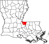
 Location in the U.S. state of Louisiana |
|
 Louisiana's location in the U.S. |
|
| Founded | 1824 |
| Named for | Marie Felice de Gálvez |
| Seat | St. Francisville |
| Largest town | St. Francisville |
| Area | |
| • Total | 426 sq mi (1,103 km2) |
| • Land | 403 sq mi (1,044 km2) |
| • Water | 23 sq mi (60 km2), 5.3% |
| Population (est.) | |
| • (2015) | 15,385 |
| • Density | 39/sq mi (15/km²) |
| Congressional district | 5th |
| Time zone | Central: UTC-6/-5 |
| Website | wfparish |
West Feliciana Parish (French: Paroisse de Feliciana Ouest) is a parish located in the U.S. state of Louisiana. As of the 2010 census, the population was 15,625. The parish seat is St. Francisville. The parish was established in 1824.
Feliciana Parish was one of two 19th-century Louisiana parishes to be divided into East and West, the other being Carroll Parish.
West Feliciana Parish is part of the Baton Rouge, Louisiana, Metropolitan Statistical Area.
The River Bend Nuclear Generating Station, operated by Entergy Nuclear, is located in West Feliciana Parish below St. Francisville. It produces approximately 10 percent of the total electric power demand in Louisiana.
The Louisiana State Penitentiary is also located in the Parish, in Angola.
Following the founding of the Bayou Sara settlement by Franciscan/Capuchin monks in the late 17th century, the area was explored further by Spain, France, and Great Britain. The original settlement has been covered over by waters of the Mississippi River, which shifted course.
After 1763, when France was defeated by Britain in the Seven Years' War, it ceded this part of La Louisiane to Great Britain, which included it in its West Florida province. Spain gained control of the area in about 1780 – during the American Revolutionary War – and maintained its authority in the area for the next three decades.
...
Wikipedia
