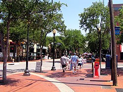
West End Historic District, Dallas, Texas
| West End Historic District | |
|---|---|

Tourists in the West End stroll down Market Street
|
|
 Location in Dallas |
|
| Country | United States |
| State | Texas |
| Counties | Dallas |
| City | Dallas |
| Area | Downtown |
| Elevation | 423 ft (129 m) |
| ZIP code | 75202 |
| Area code(s) | 214, 469, 972 |
| Website | www |
|
Westend Historic District
|
|
| Location | Bounded by Lamar, Griffin, Wood, Market, and Commerce Sts., Dallas, Texas |
| Coordinates | 32°46′44″N 96°48′21″W / 32.77889°N 96.80583°WCoordinates: 32°46′44″N 96°48′21″W / 32.77889°N 96.80583°W |
| Area | 67.5 acres (27.3 ha) |
| Built | 1891 |
| Architect | Multiple |
| Architectural style | Chicago, Late 19th and Early 20th Century American Movements, Romanesque |
| NRHP Reference # | 78002918 |
| Added to NRHP | November 14, 1978 |
The West End Historic District of Dallas, Texas, is a historic district that includes a 67.5-acre (27.3 ha) area in northwest downtown (United States), generally north of Commerce, east of I-35E, west of Lamar and south of Woodall Rodgers Freeway. It is south of Victory Park, west of the Arts, City Center, and Main Street districts, and north of the Government and Reunion districts. The district is listed on the U.S. National Register of Historic Places as Westend Historic District. The area is also a Dallas Landmark District.
The area that would become the West End originally consisted simply of a trading post, established by John Neely Bryan. In July 1872, the Houston & Texas Central Railroad arrived in downtown, attracting manufacturing companies whose warehouses would come to define the architecture of the West End.
The district reached nationwide prominence in the 1960s, when President John F. Kennedy was assassinated in a Presidential motorcade traveling through Dealey Plaza. While the assassination brought the attention to the West End, the district's economy still struggled, with many businesses leaving the city center for suburban locations.
...
Wikipedia

