West End, Surrey
| West End | |
|---|---|
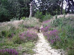
 A sandy part of West End Common notable for endemic heather (ericaceae) |
|
 Village hall |
|
| West End shown within Surrey | |
| Area | 14.52 km2 (5.61 sq mi) |
| Population | 4,693 (Civil Parish 2011) |
| • Density | 323/km2 (840/sq mi) |
| OS grid reference | SU9361 |
| Civil parish |
|
| Shire county | |
| Region | |
| Country | England |
| Sovereign state | United Kingdom |
| Post town | WOKING |
| Postcode district | GU24 |
| Dialling code | 01483 or 01276 |
| Police | Surrey |
| Fire | Surrey |
| Ambulance | South East Coast |
| EU Parliament | South East England |
| UK Parliament | |
West End is a village and civil parish in Surrey Heath, Surrey, England between the towns of Camberley and Woking, 4 miles (6.4 km) west and east respectively. The village until the mid 20th century consisted of little-farmed smallholdings amid substantial common land – West End Common to the west is comparable in size to Chobham Common to the north, and both dwarf the built-up heart of the village. West End Common includes training ranges of the British Army and is separated by a smaller public area, Brentmoor Heath, which shares in naturally wet, acid heathland, a rare soil type. In geology, the Bagshot Formation is apparent in parts of the village.
West End lies between Bagshot and Brookwood railway stations, 3 miles (4.8 km) away. The River Bourne runs through the village from its sources to the immediate west. West End and Bisley have little commerce and industry compared to adjoining settlements, with parks, grassland areas and separated by Green Belt buffers. A golf course, plant nurseries and farms adjoin the clustered village centre.
Nearby lands were settled in prehistoric times, evidenced within this civil parish, with a megalithic barrow on Westend Common.
West End may have obtained its name because it was the west of Chobham, 2 miles (3.2 km) ENE. The 1845 map reproduced by EJ Willson provides boundaries at that date. Its direct predecessor named Westend was in 1870–72 described by John Marius Wilson as "a tything in Worplesdon parish, Surrey; 3¼ miles NW of Guildford. Pop., 341." A dependency on Worplesdon church, as its tything, is attested in the medieval period until the late 19th century, after which the area formed part of the parish of Chobham.
...
Wikipedia

