West Carrollton, Ohio
| West Carrollton, Ohio | |
|---|---|
| City | |

Aerial view of West Carrollton/ Miamisburg
|
|
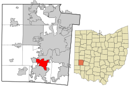
 Location in Montgomery County and the state of Ohio. |
|
| Coordinates: 39°40′5″N 84°14′53″W / 39.66806°N 84.24806°WCoordinates: 39°40′5″N 84°14′53″W / 39.66806°N 84.24806°W | |
| Country | United States |
| State | Ohio |
| County | Montgomery |
| Government | |
| • Mayor | Jeffery W. Sanner |
| Area | |
| • Total | 6.66 sq mi (17.25 km2) |
| • Land | 6.44 sq mi (16.68 km2) |
| • Water | 0.22 sq mi (0.57 km2) |
| Elevation | 702 ft (214 m) |
| Population (2010) | |
| • Total | 13,143 |
| • Estimate (2012) | 13,099 |
| • Density | 2,040.8/sq mi (788.0/km2) |
| Time zone | Eastern (EST) (UTC-5) |
| • Summer (DST) | EDT (UTC-4) |
| ZIP code | 45449 |
| Area code(s) | 937 |
| FIPS code | 39-83111 |
| GNIS feature ID | 1065462 |
| Website | www.westcarrollton.org |
West Carrollton is a city in Montgomery County, Ohio, United States. The population was 13,143 at the 2010 census. It is part of the Dayton Metropolitan Statistical Area. The Great Miami River runs through the town and forms most of its northern border.
West Carrollton is located at 39°40′5″N 84°14′53″W / 39.66806°N 84.24806°W (39.668050, -84.247991).
According to the United States Census Bureau, the city has a total area of 6.66 square miles (17.25 km2), of which 6.44 square miles (16.68 km2) is land and 0.22 square miles (0.57 km2) is water.
As of the census of 2010, there were 13,143 people, 5,973 households, and 3,378 families residing in the city. The population density was 2,040.8 inhabitants per square mile (788.0/km2). There were 6,522 housing units at an average density of 1,012.7 per square mile (391.0/km2). The racial makeup of the city was 86.8% White, 8.9% African American, 0.3% Native American, 1.1% Asian, 0.9% from other races, and 2.0% from two or more races. Hispanic or Latino of any race were 2.6% of the population.
...
Wikipedia
