Wesley Chapel, Florida
| Wesley Chapel | |
|---|---|
| CDP | |
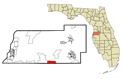
 Location in Pasco County and the state of Florida |
|
| Coordinates: 28°10′43″N 82°21′2″W / 28.17861°N 82.35056°WCoordinates: 28°10′43″N 82°21′2″W / 28.17861°N 82.35056°W | |
| Country | United States |
| State | Florida |
| County | Pasco |
| Area | |
| • Total | 6.1 sq mi (15.8 km2) |
| • Land | 6.1 sq mi (15.7 km2) |
| • Water | 0 sq mi (0.1 km2) |
| Elevation | 108 ft (33 m) |
| Population (2010) | |
| • Total | 44,092 |
| • Density | 933/sq mi (360.2/km2) |
| Time zone | Eastern (EST) (UTC-5) |
| • Summer (DST) | EDT (UTC-4) |
| ZIP codes | 33543-33544-33545 |
| Area code(s) | 813 |
| FIPS code | 12-75875 |
| GNIS feature ID | 0294231 |
Wesley Chapel is a census-designated place (CDP) in Pasco County, Florida, United States. Wesley Chapel is considered part of the Tampa Bay Area metro. The population was 44,092 at the 2010 census. In 2003, some residents of Wesley Chapel started a movement to incorporate the community (including areas not in the official CDP). This "city," which would have been the largest and most populous in Pasco County, never materialized.
Wesley Chapel is located at 28°10′43″N 82°21′2″W / 28.17861°N 82.35056°W (28.178688, -82.350676).
According to the United States Census Bureau, the CDP has a total area of 6.1 square miles (16 km2), of which 6.1 square miles (16 km2) is land and 0.04 square miles (0.10 km2) (0.49%) is water.
Residents choose the area because of its proximity to Interstate 75 and Interstate 275, 25 miles north of Downtown Tampa, and other major locales. Adjacent to its south is the region of New Tampa, part of incorporated Tampa.
As of the census of 2010, there were 44,092 people, 15,745 households, and 11,841 families residing in the CDP. There were 17,764 housing units . The racial makeup of the CDP was 74.97% White, 11.39% African American, 0.25% Native American, 5.72% Asian, 0.11% Pacific Islander, 3.97% from other races, and 3.57% from two or more races. Hispanic or Latino of any race were 20.12% of the population.
...
Wikipedia
