Weedon Bec
| Weedon Bec | |
|---|---|
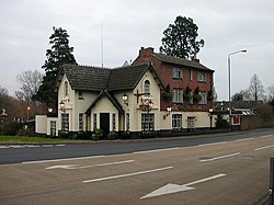
 The Crossroads public house |
|
| Weedon Bec shown within Northamptonshire | |
| Population | 2,706 (2011 Census) |
| OS grid reference | SP629596 |
| • London | 68 miles (109 km) |
| Civil parish |
|
| District | |
| Shire county | |
| Region | |
| Country | England |
| Sovereign state | United Kingdom |
| Post town | NORTHAMPTON |
| Postcode district | NN7 |
| Dialling code | 01327 |
| Police | Northamptonshire |
| Fire | Northamptonshire |
| Ambulance | East Midlands |
| EU Parliament | East Midlands |
| UK Parliament | |
Weedon Bec usually just called Weedon, is a large village and parish in the district of Daventry, Northamptonshire, England. It lies close to the source of the River Nene. The population of the civil parish at the 2011 Census was 2,706.
Weedon is located about 6 miles (9.7 km) south-east of Daventry, 7 miles (11.3 km) west of Northampton and is at the crossroads of the A5 and A45 main roads. The Grand Union Canal (1796) and West Coast Main Line both pass through the village. The village station, just north of the A45 road bridge closed in the 1960s. Between 1888 and 1963 there was a branch line just north of Weedon to Leamington Spa via Daventry. Although a 'Northampton Parkway' or 'Daventry Parkway' railway station on the site of the former station has been mooted from time to time, there have never been any firm plans.
Lower Weedon and Upper Weedon are to the south of the village. The northern boundary of the village follows the A45 to the west, then south to just outside Everdon, then skirts Everdon Wood and Everdon Stubbs, and borders Stowe Nine Churches to the south-east, and lies to a short distance east of the A5 up to the A45, next to Flore parish. To the south of the parish is the 162m Weedon Hill. The village is close to the boundary of South Northamptonshire and Daventry district.
...
Wikipedia

