Wayanad district
|
Wayanad district വയനാട് ജില്ല |
|
|---|---|
| District | |

Wayanad scenery on NH 766 Kozhikode-Kollegal
|
|
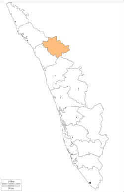
 Location in Kerala, India |
|
| Coordinates: 11°36′18″N 76°04′59″E / 11.605°N 76.083°ECoordinates: 11°36′18″N 76°04′59″E / 11.605°N 76.083°E | |
| Country |
|
| State | Kerala |
| Headquarters | Kalpetta |
| Government | |
| • Member of Parliament | M I Shanavas |
| • District Collector | B S Thirumeni IAS |
| • District Panchayat President | Ushakumari |
| • District M.L.A's |
Sulthan Bathery : I.C Balakrishnan Kalpetta:C K Saseendran Mananthavady : O.R Kelu |
| Area | |
| • Total | 2,131 km2 (823 sq mi) |
| Population (2011) | |
| • Total | 816,558 |
| • Density | 380/km2 (990/sq mi) |
| Languages | |
| • Official | Malayalam, English |
| Time zone | IST (UTC+5:30) |
| ISO 3166 code | IN-KL |
| Vehicle registration | KL-12, KL-72, KL-73 |
| Website | www |
Wayanad District is a district in the north-east of Kerala state, India with headquarters at the town of Kalpetta. The district was formed on 1 November 1980 as the 12th district in Kerala by carving out areas from Kozhikode and Kannur districts. The district is 3.79% urbanised, with three municipal towns Kalpetta, Mananthavady and Sulthan Bathery.
Wayanad district is in the southern tip of the Deccan Plateau. Part of the Western Ghats is in the district. In the centre of the district hills are lower in height while the northern area has high hills. The eastern area is flat and open.
The region was known as Mayakshetra (Maya's land) in the earliest records. Mayakshetra evolved into Mayanad and finally to Wayanad. The Folk etymology of the word says it is a combination of Vayal (paddy field) and Naad (land), making it 'The Land of Paddy Fields'. There are many indigenous tribals in this area. It is set high on the Western Ghats with altitudes ranging from 700 to 2100 m.
According to archaeological evidence, the Wayanad forests have been inhabited for more than 3,000 years. Historians are of the view that human settlement existed in these parts for at least ten centuries before Christ. Much evidence of New Stone Age civilisation can be seen in the hills throughout the present day Wayanad district. Recorded history of this district is available from the 18th century. In ancient times, this land was ruled by the Rajas of the Veda tribe.
The Kutumbiyas:
...
Wikipedia
