Wawona, California
| Wawona | |
|---|---|
| Census-designated place | |

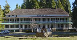
The Wawona Hotel
|
|
| Location in California | |
| Coordinates: 37°32′13″N 119°39′23″W / 37.53694°N 119.65639°WCoordinates: 37°32′13″N 119°39′23″W / 37.53694°N 119.65639°W | |
| Country |
|
| State |
|
| County | Mariposa |
| Area | |
| • Total | 6.345 sq mi (16.434 km2) |
| • Land | 6.345 sq mi (16.434 km2) |
| • Water | 0 sq mi (0 km2) 0% |
| Elevation | 3,999 ft (1,219 m) |
| Population (2010) | |
| • Total | 169 |
| • Density | 27/sq mi (10/km2) |
| Time zone | Pacific (PST) (UTC-8) |
| • Summer (DST) | PDT (UTC-7) |
| ZIP code | 95389 |
| Area code | 209 |
| GNIS feature IDs | 1652868, 2583183 |
Wawona (formerly, Big Tree Station, Clark's Station, Clarks Station, Wah-wo-nah, and Clark's Ranch) is a census-designated place in Mariposa County, California. It is located 18 miles (29 km) east of Mariposa, at an elevation of 3999 feet (1219 m). The population was 169 at the 2010 census.
Wawona is located entirely within Yosemite National Park, as it preceded the founding of the park as a national recreation area. It has approximately 160 year-round residents. The number of inhabitants increases dramatically during peak tourist seasons, due to the large number of rental cabins in the town. It is located at 37°32′13″N 119°39′23″W / 37.53694°N 119.65639°W.
It was known to the local Native American Miwok in their language as Pallachun ("a good place to stay"). The origin of the word Wawona is not known. A popular story claims Wawō'na was the Miwok word for "big tree", or for "hoot of the owl", a bird considered the sequoia trees' spiritual guardian.
Galen Clark, who helped gain preservation legislation for Mariposa Grove and what became Yosemite National Park, occupied this area in 1855. He established a tourist rest and modest ranch in 1856. Clark sold the property to the Washburn brothers in 1874, who built a larger hotel in 1876, adding to it later. Hotel keeper Jean Bruce Washburn named the resort property Wawona in 1883.
The town is located on the south fork of the Merced River, at an elevation of approximately 1300 m (4000 feet). It is on State Route 41, the main highway from Fresno to Yosemite Valley.
...
Wikipedia

