Waverly, Tennessee
| Waverly, Tennessee | |
|---|---|
| City | |

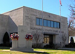
Humphreys County Courthouse in Waverly
|
|
 Location of Waverly, Tennessee |
|
| Coordinates: 36°5′9″N 87°47′13″W / 36.08583°N 87.78694°WCoordinates: 36°5′9″N 87°47′13″W / 36.08583°N 87.78694°W | |
| Country | United States |
| State | Tennessee |
| County | Humphreys |
| Incorporated | 1838 |
| Named for | Waverley Novels of Sir Walter Scott |
| Area | |
| • Total | 8.77 sq mi (22.7 km2) |
| • Land | 8.77 sq mi (22.7 km2) |
| • Water | 0.0 sq mi (0 km2) |
| Elevation | 535 ft (163 m) |
| Population (2010) | |
| • Total | 4,105 |
| • Density | 468.1/sq mi (180.7/km2) |
| Time zone | Central (CST) (UTC-6) |
| • Summer (DST) | CDT (UTC-5) |
| ZIP code | 37185 |
| Area code(s) | 931 Exchange: 296 |
| FIPS code | 47-78560 |
| GNIS feature ID | 1273950 |
Waverly is a city in and the county seat of Humphreys County, Tennessee, United States. The population was 4,105 at the 2010 census.
Waverly was established by Steven Pavatt as a stop along the stage coach road between Nashville and Memphis in the early 19th century. Pavatt was a fan of the author Sir Walter Scott, and named the community after Scott's Waverley Novels. When Humphreys County was created in 1803, Reynoldsburg, located northwest of Waverly along the Tennessee River, was chosen as the county seat. However, when county lands on the west bank of the Tennessee split off to become part of the newly created Benton County in 1835, the Humphreys County seat was moved to Waverly, which had become the more central location in the county. A courthouse was built in 1836, and the town was officially incorporated in 1838.
Like most of Middle and West Tennessee, Waverly was staunchly pro-Confederacy during the American Civil War. Humphreys County voted unanimously in favor of secession in 1861. Union troops occupied the town in 1863 to guard the railroad between White Bluff and Johnsonville (now Old Johnsonville), the latter being a Federal supply depot and transfer station. The Union troops managed to build a fort at the courthouse square, although they were constantly harassed by Confederate guerillas. On November 4, 1864, Confederate troops under Nathan Bedford Forrest attacked and destroyed the Federal depot in what became known as the Battle of Johnsonville. The battle occurred approximately 10 miles (16 km) west of Waverly at the mouth of Trace Creek.
Hurricane Mills, located a few miles south of Waverly along TN-13, was the site of a substantial mill and carding factory in the late 19th and early 20th centuries. A Mississippian-era prehistoric village (known as the Duck River Temple Mounds or Link Farm Site) and a farm owned by Jesse James were both located near the Link farm site in the vicinity of Hurricane Mills.
...
Wikipedia
